.
August 8, 2009, about twenty-four weeks ago.
It was going to be a warm day -- up in the 90s, but I wanted to get out to see a couple of sights that were new to me.
I check the oil, tires, and coolant, saddle up the trusty steed, and start out for my usual Saturday morning ride. I have gotten into the habit of riding on Saturdays because I can spend a few hours out riding and seeing the local points of interest. During the week, I commute a short way to work, which is enough to barely keep my riding reflexes in working order. I try not to go riding on Sundays, so I can devote time to church and family.
By the way, the check of all systems before jumping on and riding is quite important. If you don't do that, you could be in for a rude surprise that may include the word tarmac.
Today I ride from Easley up through Pumpkintown on SC-135, to
SC-11, the Cherokee Hills Scenic Highway. (Pushpin "B" on the map.) Pumpkintown hasn't changed much since
my first time through in February of 2009: It is still a sleepy little crossroads with this fruit stand, and a restaurant across the road.


At Pumpkintown, I turn west on SC-288. This is a slightly curvy road with several blind hillcrests where you cannot be sure which way the road turns on the other side. There are few advisory signs to give me a clue, so I take it relatively slow. This road ends near the
Holly Springs Country Store on SC-11, the meeting place for most bikers in this part of the world. (Pushpin "C" on the map.) I stop for a few minutes, but don't see anyone else to ride with, so I continue on.
My first planned destination is
Twin Falls, also called Reedy Cove Falls, Rock Falls or Eastatoe Falls. To get there, I head north on SC-178. This is a favorite twisty route for the sportbikers, especially, though you can find almost any type of conveyance on this road including tractor trailer trucks, so use care. The turns are fairly well marked with advisory speeds and curve directions. In summer, there is a photographer,
Patrick Welch, who stakes himself out on this road further to the north. He
caught me riding by back in June of 2009.
(Actually, Bucky rode by several times that day.)
Today, however, I turn left at Cleo Chapman Road (the Google map shows this incorrectly as Eastatoe Community Road), 3.2 miles north of SC-11. This turn is on the south side of a seedy roadhouse called Bob's Place or, alternatively, Scatterbrains. You can't miss it, as they say.
This place is a favorite with bikers, but it is beyond me how anyone could take a drink and ride a motorcycle, let alone ride one on a twisty road.
The turn is across traffic coming around a tight blind bend, so I use care.
From here I travel down this narrower twisty road for about two miles, then turn right onto Eastatoe Community Road
(the real thing this time) and go another 1.2 miles. Waterfalls Drive is on the right, and is one of those barely paved roads where the ground peeks through and there are patches of gravel scattered about. I
bear left at the first fork, then bear right at the edge of the woods. Here, the road turns to gravel. I park in the lot at the end of the road just before the gate. (See Pushpin "F" on the map.) Whew, that was an involved description, wasn't it? It is easier than it sounds, really.
I find a reasonably level spot, throw down my kickstand plate so it doesn't sink into the gravel and let my bike down, then dismount. You can see the gate that leads to the falls trail in the background below. It looks as though the gravel road used to go further, beyond the gate, probably at least to the falls viewpoint.

I almost never leave my helmet on the handlebar like this, because it is so easy for someone to steal it or to knock it onto the ground, and the handlebar end could cause the foam liner to deform, reducing its effectiveness in a crash. For some reason, I make an exception today.
I take my camera and start walking down the trail. It is an easy trail with good surface and only slight grades. It follows a stream that gurgles and babbles to give you company as you walk.
This tree must have had a hard time getting started. Look at those roots.

Along the path is a waterwheel dedicated to the memory of one Buck Hinkle.

Buck Hinkle was actually Thomas Dover Hinkle who died Dec. 7, 2002 at age 84, and who lived on Eastatoe Community Road, very near here.
This is a much
better photograph, taken January 17, 2010 by local photographer
David W. Hopkins.

At the end of the trail, there is a wooden shelter with benches around the inside from which to view the falls.
Here you can see why they call it Twin Falls.
There are actually two falls, adjacent to one another. It is interesting that they are quite different from one another -- fraternal twins, at best, I'd say. The one on the left is a free fall of seventy-five feet almost all the way down. The one on the right cascades amongst rocks and outcroppings on its way down. You really do get a two-for-one sight here.
By the way, did you notice the couple sitting near the base of the falls?
Here they are.

They are quite engrossed in one another, and continue to be during the entire time I am viewing the falls. I'm certainly glad I'm not intruding.
The weather has been very dry for many months, so the water flow over the falls is meager today.
This is another
photograph taken January 17, 2010 by
David W. Hopkins.
The flow is much greater in Mr. Hopkins' photo because the drought has been broken by extensive rain, some very recently.
There is a steep trail that runs beyond the platform and to the left side of the falls, but I am not game to climb it in my riding boots. I hear that there are some twisted rails above the falls, along Reedy Cove Creek, that are from a logging railroad run by the Appalachian Lumber Company in the 1920s, now long abandoned.
I drink a bottle of water while I enjoy the scenery, then I make my way back along the trail to the parking area. It hasn't cooled off any, that's for certain, and the exertion of walking has caused me to work up some sweat. Fortunately, my bike is mostly in the shade and my helmet is fairly cool.
I gear up again and retrace part of my route, but I turn right on Cleo Chapman Road instead of left. (Pushpin "E" on map.) This takes me through an area that was served by a faithful mail carrier who has been immortalized both in the road name and on a stone marker. (Pushpin "G" on map.)

She was certainly reliable, having traversed her 46-mile route for nearly fifty years, missing only one day -- said to be the day she bore a child. I wish government employees were all as dedicated as she was.
I have to turn sharply left (See Pushpin "G") because there is gated community toward the right with a guard at the gate. This mountainous area, and the lakes to the west, have become popular for high-end homes, and this is one of the more exclusive neighborhoods, called Cliffs at Keowee Vineyards. They won't let the likes of me in unless I have been invited. (I have not received my invitation as yet.)
Edit, February 26, 2010: They will let you through the gate if you are visiting the marina on Lake Keowee or McKinney Chapel and cemetery.
My route continues on Roy F. Jones Road, and runs down to
SC-11, the
Cherokee Foothills Scenic Highway, again. (Pushpin "H" on map.) I turn right, westward, and cruise along on this smooth, wide, relatively straight, two-lane road. I run swiftly (but not too swiftly, as there are motorcycle patrolmen who frequent this road, since it is easy for your speed to get away from you) for almost seven miles to the sign for Devil's Fork State Park. I turn right on Boone Creek Road.
Devil's Fork State Park is located on Lake Jocassee. The lake exists for hydro power, domestic water, and for recreation. This is a favorite place for
SCUBA divers to
practice as well. I stop for a few minutes to gaze at the lake, drink some more water, and eat a granola bar. (Pushpin "I" on the map.) I leave the park and find my way back to SC-11, then head west again.
I go about ten miles to
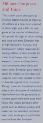
Oconee Station State Historic Site. This is the second time I have come here. The last time, I got lost and nearly ran out of gas before I asked a bicycle rider how to escape. There are two standing structures here, the blockhouse and the William Richards home. The blockhouse was built in 1792 as a military post to protect settlers against the Cherokee Indians and later to protect Indians against settler encroachment. The troops were removed in 1799, the last blockhouse to be decommissioned in SC. In 1805, William Richards, from Ireland, built a brick home next door and established a trading post using the blockhouse. There is also a small pond, hiking trails, and a waterfall, Station Cove Falls.
Some historical info:

I walk the short path to the structures and find a docent explaining the history of them. I can't imagine living in such primitive structures, but I suppose it was the best available at the time, and much appreciated by those who lived here.
Info posted in the parking area:

William Richard's two story brick home. Most contemporary structures were built of logs. Mr. Richards was an Irish immigrant who built it in 1805.

The stone blockhouse, on the right, used as a military post between 1792 and 1799. Its initial purpose was to protect white settlers in the area from Indian attack.

Front view of the blockhouse.

From the
Historical Marker Database website:
"As Europeans and European-American settlement expanded across South Carolina, the 'frontier' moved west. Beginning in 1792, Oconee Station and six similar military outposts served as the westernmost defensive points for new settlers. Scouts based in these stations roamed the frontier areas and served as an early warning network of imminent Indian attacks, giving the alarm to local white settlers.
This site was the only station on the South Carolina frontier that remained in operation after 1796. Its use by the military ended after 1799, when the threat of a major Indian attack became highly unlikely. Oconee Station, with its history as a military fort and trading post, reveals the complex and changing relationships between Southeastern Indians and white settlers, as the whites gained land and as the Indian Territory was pushed westward."
|
By Brian Scott, November 28, 2008 |
|
|
|
|
|
|
|
| 
By Brian Scott, November 28, 2008 |
|
|
|


Once I have examined the area, I walk back to the parking lot, drink some more water and get ready to go. It sure is hot today. Getting moving again will help cool me off.
I follow the road back part of the way, but this time stay on Oconee Station Road until I hit the metropolis of Picket Post. (See Pushpin "L" on the map.) I blink and miss it. Oh well, maybe next time I'll spot it.
I get on SC-11 again and go about two miles to hit SC-183. This will take me back toward home. This is a fairly straight road that has one more stop on it for me today.
The
Duke Power Oconee Nuclear Station has a visitor center called the
World of Energy. I have stopped here several times to rest, and look at their rotating displays. (See Pushpin "N" on the map.)
Today, they have a photography exhibit, and, as it happens, the local photographer
Patrick Welch we discussed above has some of his work on display. Here are two of them.
The first is
Caesar's Head, taken from SC-11.

The second is of two sportbikers, on US-178 at the same place he took the pictures of me.
 Headed south on the south curve.
Bucky in June of 2009.
 Headed south on the south curve.
Those other guys were going slightly faster than Bucky was, don't you think?
You can see the reflection of my suit in both of Patrick's photographs.
On my way back, I cross a bridge over the Keowee River on SC-183, and see where another bridge used to stand. Its deck is long gone, but the abutments are still here. Only, there is something wrong with one of them. It has toppled over. I wonder whether it fell while the bridge was in use, condemning the bridge, or whether it fell while the deck as being removed, or whether it fell after the deck was already gone.

I'll bet that made some splash.
I pass the DMV closer to home, and stop in for some
low speed practice on their motorcycle range. I do all right, but the practice helps me improve a bit every time I do some.
Once I reach home, the thermometer has climbed to 91 degrees. I am a little warm, but my day has been enjoyable, out in God's creation. I have traveled 115 miles.
.
.
Be sure to click on "Older Posts" below at right to see more of Bucky's Ride.
.


