Friday, March 5, 2010

Dressing for Cold Weather Riding -- Take Two

.
Back in November, I wrote about how I keep warm when riding in cold weather. That posting started out like this, with a great photo of a rider in a snowy landscape. It worth seeing again, so here it is, along with the starting sentence.

This...

Found on AdV Rider Forum

doesn't occur [very often] in South Carolina.

All of the gear I described back then does a fine job of keeping my skinny frame warm down to about thirty-five degrees without the aid of electrically heated clothing. I have a pair of heated grips that work well in keeping the palms of my hands warm, but the backs of my hands and my fingers still get very cold at that low temperature even with my non-perforated leather gloves and the Antifreeze liners.

A few months back, I scored a set of vintage Hippo Hands on ebay. These are fleece-lined leatherette covers for the grips, controls, and hands. The company never made a pair especially for my Ninja 650R, so I took a chance that I could make this set work. Mine is probably fifteen or twenty years old.

Here is a picture of the handlebars and controls without the Hippo Hands. You can see the heated grip controller in the center.


I tried installing the Hippo Hands and had some difficulty with the right one providing enough room inside for the front brake master cylinder reservoir. After a bit of maneuvering, this was overcome, and I could snap and Velcro the opening closed over it. A Velcro strap helps close off the gaps around the bars, cables and wiring. The left Hippo Hand went on easily, since there is not much hardware attached to that side of the handlebars.

My little redheaded friend will point out some of the features of the Hippo Hands.

Here is the stiffener along the outer edge that helps them keep their shape. It is probably a flexible plastic rod sewn into the hem.


The slotted opening that allows the Hippo Hand to slip over the controls is secured both with snaps and Velcro to keep the wind out.


The inner part of the slotted opening closes up most of the space around the handlebar, cables, and wiring. It has Velcro on the edges and a Velcro strap that wraps around the bar.


Once I had them in place, I did a quick test ride and found that the wind caused the left Hippo to press down rather firmly on the back of my hand. I had some difficulty bringing my fingers up over the clutch lever. Further, I was afraid that the wind would press on the lever and cause the clutch to slip. The right Hippo seemed fine, because of the stiffening along its edge and the tight fit over the brake master cylinder.

I cogitated on this problem for a few days.

I considered buying a set of plastic hand guards, but they don't make a set especially for the Kawasaki Ninja 650R and the generic ones don't fit very well without moving the brake and clutch levers toward the center to make room for the bar clamps. Anyway, they do cost money.

I also considered bending up some stiff wire to better support them against the wind, but that idea was headed down the path of a significant design-and-build project.

As is usual with me, I think about how to solve a problem for some time, and while doing so, look around for ideas. A walk through a hardware store or a search in industrial and motorcycle catalogs sometimes gives me a kernel of a fix. In this case, I rummaged through my considerable stock of brackets I have salvaged and bought new.

I came up with a pair of 6" long, 1" wide, and 3/16" thick angle brackets that were brand new. I sized them up by eye, then began engineering a solution. By slightly enlarging one of the screw holes, the bracket could be mounted between the bar end and the bar-end weight. I used several flat washers to provide clearance for free movement of the throttle tube, and used a longer socket-head cap screw to reinstall the weight. Washers were also used between the left weight and the angle bracket so that weight would fit properly.

I positioned the angle brackets so they were slightly higher than the levers and tightened up the bar-end screws. I slipped a section of foam pipe insulation over the brackets to prevent chafing of the Hippo Hand interior.

Here is one of the angle brackets.


Not very pretty, but functional, and it will be covered up later.

Here are some pictures of the Hippo Hands as they look when installed.


OK fine, we've heard enough about how you installed them. Now, how do they work, Bucky?

Well, I tried them out this last Saturday on a ride to eastern Georgia. The temperature when I started out was 35 degrees. I wore my lighter gloves, a pair of Shift Carbines, and turned my grip heaters to their medium setting. I could feel a distinct difference, even while the grip heaters were just beginning to supply warmth. My hands weren't becoming chilled nearly as rapidly as they would have with the grips set on high and with my non-perforated leather gloves and Antifreeze liners on.

When the heat from the grips was fully available, my hands were not just comfortable, they were toasty warm.

As the air temperature warmed to the upper fifties over the course of the day, my hands stayed comfortable and my dexterity remained very good. Even at fifty-five degrees, they were not too hot.

The angle brackets held the Hippo Hands away from the brake and clutch levers, and provided space for my hands to reach over the levers for actuation.

One thing you must be comfortable with is not being able to see your hands on the controls. Surprisingly, I found that I was occasionally trying to look at my hands when I manipulated a control. Of course, I could see nothing but the outside of the Hippo Hands. Nevertheless, I succeeded in operating all of the controls over the ride, and had no real trouble.

The openings of the Hippo Hands are large enough so that there is no difficulty sliding your gloved and jacketed hands and arms into and out of them. The openings stay open nicely when your hands are not inside.

In fact, the thought has crossed my mind that an enterprising bird or chipmunk might take up residence in them if I were to leave the bike parked outside for very long. It would certainly be a surprise to stick my hand in there, only to find that I am invading an animal's home. I'll have to watch for that.

And here is a picture from a frosty/foggy morning.


Yes, that is ice, formed while riding through a cold fog.

By the way, there is a company still making Hippo Hands, but it is said to be a successor to the original. The new company doesn't make a set for my Ninja either.

---------------------------------------------------------------------------------

Here are some cheaper alternatives to buying new, but check the fit before you do so. You will probably need hand guards or the like to prevent interference with the clutch and brake levers.

Tucker Rocky Biker's Choice Quadboss Hand Warmers shown here on Redlegsrides' BMW RT.

Oxford Handlebar Delux Muffs.

Tusk Hand Mitts

Rick, on his Keep the Rubber Side Down blog, has a short entry here.

---------------------------------------------------------------------------------

One other thing I did differently on Saturday's ride was to wear a pair of polyester pile bib pants (military surplus, OVERALL, BIB, COLD WEATHER) instead of the Extended Cold Weather System [ECWS] fleeced polypropylene military surplus knit pants under my leathers. The pile is more like wool fleece and provides more insulation, but without the itching and care required of wool. The overall I have was made by The North Face -- apparently they have or had a division that makes military apparel.


They have zippers on the outside of the legs, and a crotch zipper that goes all the way around. I was concerned about the zippers causing trouble, but they do not seem to.


My set of Fieldsheer two-piece leathers is large enough to accommodate all this underneath, and I look like a muscular bloke instead of a 97 pound weakling when I am wearing all of this stuff, too.

For all of you who are too young to know the significance of the 97 pound weakling statement:


Well, I don't look exactly like that with the gear on, mind you. ...and my underdrawers are definitely not like his.


Anyway, the pile pants are nice and warm for temperatures below forty degrees, and the Hippo Hands are a definite improvement for cold weather riding.

Try 'em, you'll like 'em.
.
See also: Dressing for Cold Weather Riding -- Take Three.
.

.

Tuesday, March 2, 2010

Tech Tip -- Garage Door Opener

.
One of the difficulties of riding a motorcycle is having to trigger the automatic garage door opener upon leaving and upon returning.

I have found myself borrowing the radio control from the car, fumbling around with it in my tank bag, then forgetting to put it back into the car when I am through riding. Another way of opening and closing the door is to use the keypad adjacent to the door on the outside, but trying to finger the code into the keypad when I have my motorcycle gloves on is difficult, resulting in several misses before success is achieved.

Here is a technical solution to the problem using an Autoswitch Model AS5PG2 control that wires into one of the bar switches to actuate the door's remote control.

Here is a video of it in action:


Problem solved!


Another method of solving the same problem is shown here.

Problem solved again!
.

Friday, February 26, 2010

Harangue -- South Carolina DOT Waste

.
harangue: An impassioned, disputatious public speech; A tirade or rant, whether spoken or written; To give a forceful and lengthy lecture or criticism to someone.

A road near where I live was recently widened and paved. It is state-maintained, and it is one of those roads that used to be out in the country, but the city has grown and overtaken it. It needed to be improved, and it was getting a little bumpy in places.

If you live around here, you also know that they do not provide even one inch of drivable berm on most roads, so if you leave the tarmac, you are off the road. ...and there are ditches along many roads, so you might even be in the ditch as soon as you go off. Not a good situation for car, truck, or bike.

Widening the road was certainly welcome, and they did a nice job. They glued down center reflectors as they usually do so you can follow the many curves at night. These reflectors are protected by metal housings from traffic damage and the occasional snowplow that may need to run down the road.

All A-OK so far.

After the road widening and repaving portions of the project had been completed for a few days, they came back and glued down circular disks on the fog lines. The fog lines are the white lines that they paint along the edges of the road so you can see them better, especially in the dark or in fog.

These disks are intended to make noise when you run over them, warning you away from the edge and certain trouble if you stray further. Not a bad idea. I understand they are made of plastic, melted to stick them into place. They also appear to incorporate sand in their makeup to provide hardness and wear resistance.

Here is what they look like.


And a closeup of one of them.


Not a bad idea...except for one thing. Remember that snow we had on Friday, February 12th that kept me from riding the next day? Well, it had almost all melted when the state highway maintenance crew came down the road with the snowplow on that Saturday.

You did read correctly -- the snow was almost all melted and gone by the time they ran the plow.

So, why on earth did they waste their time and my money?

Guess what happened.

Right you are. Did you see the crack in the pavement to the left of the disk in the closeup picture above? Yep. The snowplow scraped up more than half of the fine new round blobs that had been so carefully glued to the fog lines.

See? Sheared right off.


The pieces of the disks are scattered like so many eggshells along the edges of the road. Thousands of them.


And the mowers in the summer are sure to spew some of them back out onto the road, maybe into a passing car -- or into Bucky on his motorcycle.

The shape of the blobs is almost straight sided, not tapered, so the plow has the advantage in ripping them off of the surface.

Here is a view of our fine new road -- and the broken up bumps strewn about.


Well, I was boiling mad when I saw this. My hard-earned tax dollars were wasted.

So I called the South Carolina Department of Transportation (DOT). I had a tough time finding someone to talk with, but finally found Sam Gravely in the maintenance department. I assure you that I was tactful and didn't let him have my wrath right out of the box.

Not that I wasn't strongly tempted to let loose. I was that.

I explained what I had observed, and he asked a few questions. He was familiar with this one-mile stretch of road work, and he said that he had questioned the DOT construction engineers on how his department was supposed to maintain the road in winter with these round blobs sticking up from it. He said he got no answer. Further, he said that it is usually not customary to install such devices on roads with speed limits as low as this road -- 45 MPH. I wonder why they were installed then.

By the way, Mr. Gravely was unfailingly polite and constructive in our conversation.

So, as I understand it, the dots were put down as part of the scope of work created by the DOT construction department, despite there being no way to keep from damaging them in the event of snow plowing.

I called the DOT construction engineering department to ask them why they would do such a stupid thing. (Can you tell that my anger is peaking again here?) The resident construction engineers Tommy Hendricks and Jeff Lyle were both out of the office, and they did not return my call.

So I have to conclude that they are not interested in the performance of their creation or in the waste of my money that put those little plastic blobs in their vulnerable places.

By the way, the difference in cost between a painted fog line and one with the blobs is about $0.27 a linear foot. The road section where they did this is about a mile long, so I figure that the cost increment was about $2800.

I don't know about you, but $2800 is a significant amount of money that I would not simply throw away.

South Carolina DOT, you take the cake. Let me know whether you intend to pull the same trick on the next mile of the same road now being prepared for repaving just to the north of this section.

(I should report that the center reflectors survived the plow unscathed. That is one good thing.)

--------------------------------------------------------------------------------------

While I am haranguing, here is another one: Eventually those very useful center reflectors do get broken and come loose from the road. This occurs especially along curves where they are run over the most, but are most needed.

Do you suppose that the highway department periodically inspects and replaces them? No siree. We are left to feel our way along in poor visibility conditions.

I wonder how many accidents have been caused by drivers losing track of the road in one of those curves without reflectors.

OK, I'm through for now. I want to go riding.
.

.

Tuesday, February 23, 2010

Eastatoe Falls, Oconee Station, World of Energy, Low Speed Practice

.
August 8, 2009, about twenty-four weeks ago.

It was going to be a warm day -- up in the 90s, but I wanted to get out to see a couple of sights that were new to me.

The proposed route is here:

View Larger Map

I check the oil, tires, and coolant, saddle up the trusty steed, and start out for my usual Saturday morning ride. I have gotten into the habit of riding on Saturdays because I can spend a few hours out riding and seeing the local points of interest. During the week, I commute a short way to work, which is enough to barely keep my riding reflexes in working order. I try not to go riding on Sundays, so I can devote time to church and family.

By the way, the check of all systems before jumping on and riding is quite important. If you don't do that, you could be in for a rude surprise that may include the word tarmac.

Today I ride from Easley up through Pumpkintown on SC-135, to SC-11, the Cherokee Hills Scenic Highway. (Pushpin "B" on the map.) Pumpkintown hasn't changed much since my first time through in February of 2009: It is still a sleepy little crossroads with this fruit stand, and a restaurant across the road.


At Pumpkintown, I turn west on SC-288. This is a slightly curvy road with several blind hillcrests where you cannot be sure which way the road turns on the other side. There are few advisory signs to give me a clue, so I take it relatively slow. This road ends near the Holly Springs Country Store on SC-11, the meeting place for most bikers in this part of the world. (Pushpin "C" on the map.) I stop for a few minutes, but don't see anyone else to ride with, so I continue on.

My first planned destination is Twin Falls, also called Reedy Cove Falls, Rock Falls or Eastatoe Falls. To get there, I head north on SC-178. This is a favorite twisty route for the sportbikers, especially, though you can find almost any type of conveyance on this road including tractor trailer trucks, so use care. The turns are fairly well marked with advisory speeds and curve directions. In summer, there is a photographer, Patrick Welch, who stakes himself out on this road further to the north. He caught me riding by back in June of 2009. (Actually, Bucky rode by several times that day.)
Today, however, I turn left at Cleo Chapman Road (the Google map shows this incorrectly as Eastatoe Community Road), 3.2 miles north of SC-11. This turn is on the south side of a seedy roadhouse called Bob's Place or, alternatively, Scatterbrains. You can't miss it, as they say.
This place is a favorite with bikers, but it is beyond me how anyone could take a drink and ride a motorcycle, let alone ride one on a twisty road.
The turn is across traffic coming around a tight blind bend, so I use care.
From here I travel down this narrower twisty road for about two miles, then turn right onto Eastatoe Community Road (the real thing this time) and go another 1.2 miles. Waterfalls Drive is on the right, and is one of those barely paved roads where the ground peeks through and there are patches of gravel scattered about. I bear left at the first fork, then bear right at the edge of the woods. Here, the road turns to gravel. I park in the lot at the end of the road just before the gate. (See Pushpin "F" on the map.) Whew, that was an involved description, wasn't it? It is easier than it sounds, really.

I find a reasonably level spot, throw down my kickstand plate so it doesn't sink into the gravel and let my bike down, then dismount. You can see the gate that leads to the falls trail in the background below. It looks as though the gravel road used to go further, beyond the gate, probably at least to the falls viewpoint.


I almost never leave my helmet on the handlebar like this, because it is so easy for someone to steal it or to knock it onto the ground, and the handlebar end could cause the foam liner to deform, reducing its effectiveness in a crash. For some reason, I make an exception today.

I take my camera and start walking down the trail. It is an easy trail with good surface and only slight grades. It follows a stream that gurgles and babbles to give you company as you walk.
This tree must have had a hard time getting started. Look at those roots.
Along the path is a waterwheel dedicated to the memory of one Buck Hinkle.
Buck Hinkle was actually Thomas Dover Hinkle who died Dec. 7, 2002 at age 84, and who lived on Eastatoe Community Road, very near here.

This is a much better photograph, taken January 17, 2010 by local photographer David W. Hopkins.


At the end of the trail, there is a wooden shelter with benches around the inside from which to view the falls.
Here you can see why they call it Twin Falls.
There are actually two falls, adjacent to one another. It is interesting that they are quite different from one another -- fraternal twins, at best, I'd say. The one on the left is a free fall of seventy-five feet almost all the way down. The one on the right cascades amongst rocks and outcroppings on its way down. You really do get a two-for-one sight here.

By the way, did you notice the couple sitting near the base of the falls?
Here they are.

They are quite engrossed in one another, and continue to be during the entire time I am viewing the falls. I'm certainly glad I'm not intruding.
The weather has been very dry for many months, so the water flow over the falls is meager today.
This is another photograph taken January 17, 2010 by David W. Hopkins.

The flow is much greater in Mr. Hopkins' photo because the drought has been broken by extensive rain, some very recently.
There is a steep trail that runs beyond the platform and to the left side of the falls, but I am not game to climb it in my riding boots. I hear that there are some twisted rails above the falls, along Reedy Cove Creek, that are from a logging railroad run by the Appalachian Lumber Company in the 1920s, now long abandoned.

I drink a bottle of water while I enjoy the scenery, then I make my way back along the trail to the parking area. It hasn't cooled off any, that's for certain, and the exertion of walking has caused me to work up some sweat. Fortunately, my bike is mostly in the shade and my helmet is fairly cool.

I gear up again and retrace part of my route, but I turn right on Cleo Chapman Road instead of left. (Pushpin "E" on map.) This takes me through an area that was served by a faithful mail carrier who has been immortalized both in the road name and on a stone marker. (Pushpin "G" on map.)


She was certainly reliable, having traversed her 46-mile route for nearly fifty years, missing only one day -- said to be the day she bore a child. I wish government employees were all as dedicated as she was.

I have to turn sharply left (See Pushpin "G") because there is gated community toward the right with a guard at the gate. This mountainous area, and the lakes to the west, have become popular for high-end homes, and this is one of the more exclusive neighborhoods, called Cliffs at Keowee Vineyards. They won't let the likes of me in unless I have been invited. (I have not received my invitation as yet.)

Edit, February 26, 2010: They will let you through the gate if you are visiting the marina on Lake Keowee or McKinney Chapel and cemetery.

My route continues on Roy F. Jones Road, and runs down to SC-11, the Cherokee Foothills Scenic Highway, again. (Pushpin "H" on map.) I turn right, westward, and cruise along on this smooth, wide, relatively straight, two-lane road. I run swiftly (but not too swiftly, as there are motorcycle patrolmen who frequent this road, since it is easy for your speed to get away from you) for almost seven miles to the sign for Devil's Fork State Park. I turn right on Boone Creek Road.

Devil's Fork State Park is located on Lake Jocassee. The lake exists for hydro power, domestic water, and for recreation. This is a favorite place for SCUBA divers to practice as well. I stop for a few minutes to gaze at the lake, drink some more water, and eat a granola bar. (Pushpin "I" on the map.) I leave the park and find my way back to SC-11, then head west again.

I go about ten miles to Oconee Station State Historic Site. This is the second time I have come here. The last time, I got lost and nearly ran out of gas before I asked a bicycle rider how to escape. There are two standing structures here, the blockhouse and the William Richards home. The blockhouse was built in 1792 as a military post to protect settlers against the Cherokee Indians and later to protect Indians against settler encroachment. The troops were removed in 1799, the last blockhouse to be decommissioned in SC. In 1805, William Richards, from Ireland, built a brick home next door and established a trading post using the blockhouse. There is also a small pond, hiking trails, and a waterfall, Station Cove Falls.

Some historical info:


I walk the short path to the structures and find a docent explaining the history of them. I can't imagine living in such primitive structures, but I suppose it was the best available at the time, and much appreciated by those who lived here.

Info posted in the parking area:


William Richard's two story brick home. Most contemporary structures were built of logs. Mr. Richards was an Irish immigrant who built it in 1805.


The stone blockhouse, on the right, used as a military post between 1792 and 1799. Its initial purpose was to protect white settlers in the area from Indian attack.


Front view of the blockhouse.


From the Historical Marker Database website:

"As Europeans and European-American settlement expanded across South Carolina, the 'frontier' moved west. Beginning in 1792, Oconee Station and six similar military outposts served as the westernmost defensive points for new settlers. Scouts based in these stations roamed the frontier areas and served as an early warning network of imminent Indian attacks, giving the alarm to local white settlers.
This site was the only station on the South Carolina frontier that remained in operation after 1796. Its use by the military ended after 1799, when the threat of a major Indian attack became highly unlikely. Oconee Station, with its history as a military fort and trading post, reveals the complex and changing relationships between Southeastern Indians and white settlers, as the whites gained land and as the Indian Territory was pushed westward."

Oconee Station Marker - Oconee Station & the William Richards House Photo, Click for full size
By Brian Scott, November 28, 2008


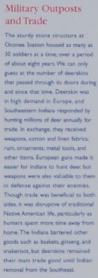
Oconee Station Marker - Military Outposts and Trade Photo, Click for full size
By Brian Scott, November 28, 2008


Oconee Station Marker - A Sharing of Material Cultures Photo, Click for full size

Once I have examined the area, I walk back to the parking lot, drink some more water and get ready to go. It sure is hot today. Getting moving again will help cool me off.

I follow the road back part of the way, but this time stay on Oconee Station Road until I hit the metropolis of Picket Post. (See Pushpin "L" on the map.) I blink and miss it. Oh well, maybe next time I'll spot it.

I get on SC-11 again and go about two miles to hit SC-183. This will take me back toward home. This is a fairly straight road that has one more stop on it for me today.

The Duke Power Oconee Nuclear Station has a visitor center called the World of Energy. I have stopped here several times to rest, and look at their rotating displays. (See Pushpin "N" on the map.)

Today, they have a photography exhibit, and, as it happens, the local photographer Patrick Welch we discussed above has some of his work on display. Here are two of them.

The first is Caesar's Head, taken from SC-11.


The second is of two sportbikers, on US-178 at the same place he took the pictures of me.

Headed south on the south curve.

Bucky in June of 2009.

Headed south on the south curve.

Those other guys were going slightly faster than Bucky was, don't you think?

You can see the reflection of my suit in both of Patrick's photographs.

On my way back, I cross a bridge over the Keowee River on SC-183, and see where another bridge used to stand. Its deck is long gone, but the abutments are still here. Only, there is something wrong with one of them. It has toppled over. I wonder whether it fell while the bridge was in use, condemning the bridge, or whether it fell while the deck as being removed, or whether it fell after the deck was already gone.


I'll bet that made some splash.

I pass the DMV closer to home, and stop in for some low speed practice on their motorcycle range. I do all right, but the practice helps me improve a bit every time I do some.

Once I reach home, the thermometer has climbed to 91 degrees. I am a little warm, but my day has been enjoyable, out in God's creation. I have traveled 115 miles.
.
.
Be sure to click on "Older Posts" below at right to see more of Bucky's Ride.
.

Monday, February 15, 2010

Snow.......Again!

.
Well, it has been about eight weeks since I have ridden. It seems like ages. The weather has conspired against me. It has been cold, rainy, and occasionally snowy and icy. When it hasn't been bad weather, I have not been able to get out for other reasons.

This last Saturday, I had planned an easy trip to see a couple of local sights and, in between, have lunch at a place I have never been. Here was the plan:

  • The Central Railway Model and Historical Association is a model railroad club that has set up its layout in a house in Central South Carolina. They hope to be something like the Apple Valley Model Railroad Club someday.

  • Sardi's Den is a restaurant in Clemson South Carolina that is supposed to have great barbecued spareribs. (I think there may be a little college in that town, too. I forget.)

  • The Lunney Museum is over in Seneca South Carolina and is located in a California-style Arts and Crafts bungalow built in 1909. It contains a collection of Victorian furniture as well as Oconee County historic memorabilia.
The ride would have been about sixty-five miles, but with three long breaks, and none of it in the mountains. It would be a "get reacquainted" ride to polish my atrophying skills.

Well, my plans were dashed when it snowed a little more than two inches the night before. I pouted a bit, but I couldn't do anything about the snow. Even though it would be melted by the next day, I try not to go out riding on Sundays. Anyway, Sunday was Valentine's Day, and I needed to be with mine, my bride of thirty-five years.

In lieu of showing you some riding pictures, I am instead posting pictures of the snowy landscape near our house:
.
Just after sunrise.

.
The river flows amongst the snow-covered branches.

.
A little rapids here.
.
A lonesome horse waits.
.
.
I have a friend who has snapped several excellent shots in his back yard. I asked him to allow me to post them here.

.
[Above two photos courtesy of Fred]
.
.
.
By the way, my Valentine gave me two nice-sized gift certificates to Cycle Gear. Isn't she the greatest?
.