Showing posts with label Table Rock. Show all posts

Wednesday, January 18, 2017

25° then 75° in the Same Week -- So Ride When You Can!

.
The weather this winter in South Carolina has been fickle.  We had snow and below freezing temperatures, then, by the end of the same week, we had mid-70s temperatures and sunny skies.

A man doesn't know how to dress for the weather these days! 

The cold and snow certainly did cut into our riding time, but I guess I should be glad that for most of the winter here it is possible to ride, with the right gear.

Here are some pictures taken in our yard on an obviously non-riding day:

Brrrr.
My wife's little garden pond.

I stayed in the house most of the time when the snow was around, since most South Carolina drivers have no earthly idea how to drive in it, and they don't have much snow removal equipment because we don't get snow very often.  They do scatter some sand and road salt around, though, to their credit.  The only bad part of that is that the sand stays on the roads for weeks afterwards creating quite a hazard for two wheels. 

Once the snow melted, the weather got summer-like, so I had to go out and make sure I ran the bike enough to charge up the battery.

Naturally that meant go for a ride.  Of maybe 70 miles or so, at least.  That should do it, wouldn't you say?  Don't want to kill that expensive battery, now do we. 


I start out from home and go northward on SC-135.  This is a easy road with only a few curves.  The riding is easy, and I make good time.  There isn't much sand on the road, so that is good.

I reach SC-8 near the thriving crossroads called Pumpkintown.  Just before I reach there (at point B on the map below), I can see Table Rock to my left in the distance.  It stands in stark contrast to the tree-lined hills that surround it.


Just look at the blue sky.  It almost looks like a painting.  In a way, it is -- God's painting, though. 

I continue on until I reach SC-11 (at point C on the map), the Cherokee Foothills National Scenic Byway.  This is a nearly straight road that runs along the southern side of the Blue Ridge Escarpment about 18 miles from Easley, SC where I live.  Lots of cruisers use this road, and the sporty bike riders use it to get to the many twisty roads to the north.

Here is a view taken from SC-11 of Table Rock: 


And a closer look from the road that runs thorough Table Rock State Park (at points D, E and F on the map): 


I go a bit further south on SC-11 to US-178 and stop at the Holly Springs Country Store (at point G on the map) to stretch and see of there are any other bikers there.  As I am surveying the parking lot, I spot a fellow I know, Tommy.  He is a few years younger than I am and rides a sport-touring bike.  Today, though he is in his cage and stopped to chew the fat with the locals on the porch at the store.

When I am through chatting with Tommy, I head back toward Easley on US-178.  They have recently patched this stretch of road, and they made it worse than it was as far as lumps and bumps.  They also created some edge traps where they replaced only part of a lane width.

That's our federal government at work.  In all fairness, they are not done yet, so I will reserve final judgment until then.  (...but I am not holding my breath.) 

Anyway, I reach the town of Pickens and head toward home on SC-8.  The DMV is along here (at point H on the map) and they have a motorcycle certification test layout in the back part of their parking lot.  I stop for a few minutes and practice my low speed maneuvers and lane changes.  I find that if I don't do this periodically, I get rusty and less sure of myself on the road when I have to use one of these techniques.

Here is an aerial view of the DMV.  See the test layout at the bottom, center of the photograph:


Here is a collage at the DMV of some GoPro screen grabs:

Makes you a little dizzy, doesn't it?

After that, I went home.  I only had time for this short jaunt of 69 miles, but it was a great day to be out on the bike. ...and the battery is now fully charged, I might say. 

Here is the map of the trip, less some of the meandering I did in between points:  

Click for larger interactive map.
.
.

Thursday, November 24, 2016

Fire!

.
It's been dry.

Very dry.

Tinder dry.

On the 10th of November, I took a short ride up SC-135 and SC-8 from Easley, SC toward the north.

This is the way I started out:


As I approach the little crossroads of Pumpkintown (Point B on the map), I notice that there is a good deal of haze in the distance.


I hadn't realized that the fire on Pinnacle Mountain had grown so much, and was generating so much smoke.  The further I go, the worse it is.  When I get to the intersection of SC-11, the Cherokee Foothills National Scenic Highway, I turn left and ride to US-178, and then a few hundred yards south to SC-288, Table Rock Road.  I turn right into the cemetery across the street from Holly Springs Baptist Church (Point D on the map, and note that Pinnacle Mountain is marked on the map).

This is what I see from the cemetery:

Click on photo for a larger view
Pinnacle Mountain is to the right.  It is the highest point entirely within South Carolina and can be reached on foot from table Rock State Park a few miles east of here. 


The fire started from a campfire on November 9, and has spread significantly.  As of November 21st, the fire is only 35% contained and now encompasses 5,100 acres.

More than 120 brave personnel are working 12+ hour shifts to put out the fire by hand, using bulldozers, off-road tankers, and chainsaws.  The fire is now the largest fire ever in Pickens County since the S.C. Forestry Commission started keeping records 90 years ago.

I am startled by a National Guard helicopter overhead carrying a red water bucket.  They are making repeated trips to Lake Olenoy at Table Rock State Park Visitor center on SC-11. I go back there by way of West Gate Road that also leads to an entrance of Table Rock State Park. 

The helicopter has stopped at the Table Rock Wesleyan Camp where the men are sleeping and getting their meals.


Notice the man sitting in the copter doorway.


I circle back to Lake Olenoy and catch the helicopter picking up water from the lake, then flying off to the fire.


I decide to see if I can view the fire from a different angle and head toward Sassafras Mountain, the highest point in South Carolina, though the mountain shares its base with both North and South Carolina.  Sassafras is also shown on the map above. 

Once I get there, I walk to the overlook.  I can see the smoke, but not the source of it. 

Here is a panorama from the overlook near the top of the mountain:

Click on photo for a larger view
And here is a 360-degree panorama from the top of the mountain.  The smoke from the fire it at the far left.  

Click on photo for a larger view
I do get to see some very nice leaf coloration on the way to Sassafras and back on US-178 north of SC-11.


I head back toward home on US-178, pass though the town of Pickens, do some practice of low speed maneuvers in my neighborhood, then put the bike away for the next time. 

Except for the fire, the day is beautiful.  It has been good to be out and about. I traveled only 88 miles, but it was worth it. 

I pray God's protection for the firefighters.


----------------------------------------------------------------------------------

Update on Thanksgiving Day. 

I went up north for a look at the progress the firefighters had made.  I went up SC-135, and SC-8, then headed over to Aunt Sues Country Corner, a tourist stop the firefighters were using as a command base.  (By the way Aunt Sue's has great ice cream when they are open.) 


There was nobody there.  I did stop and take a look at the map of the fire's progression and the map showing the various methods they had used to contain it.  These are on the signboard at the far left of the photograph below. 


Here is a closeup of the fire's progression by day:


Notice the tremendous progression of the fire on November 17, the black.  It consumed 1457 acres on that day.  The total burn had progressed to 6022 acres by November 21.  That's quite a bit more than the 5,100 acres I stated in my previous post above. 

The circled red X within the blue circle and green area toward the left of the map above is the origin of the fire -- a campfire.  It is a fearsome thing, fire, in such a dry land.

Here is a news release from November 22, that explains the then-current situation.


And here is a detailed map of the various efforts to stop it.


The orange dots are hot spots.  The black line represents containment.  The orange line is as yet uncontained. 

I ran across the landing field for the various helicopters on Table Rock Road at the Palmetto Cove Campground


There are both Blackhawk and Chinook helicopters, plus a small copter for observation.

I have never been able to see any of the fire directly because they keep the public far enough away so we don't interfere with their efforts to contain the fire.

It was another good day to be out riding.  We have a lot to be thankful for this Thanksgiving Day.  It is unfortunate that there is such an extensive fire going on. 


----------------------------------------------------------------------------------

Final Update. 

FIRE SIZE: 10,623 acres, as of Dec. 5, 2016, when it was contained.

ESTIMATED COSTS: $4.8 million

FIRE BACKGROUND: Human-caused / Nov. 9, 2016 / Table Rock State Park, 10.5 miles north of Pickens, S.C.


.
.
.

Friday, September 26, 2014

Pretty Place to Visit

.
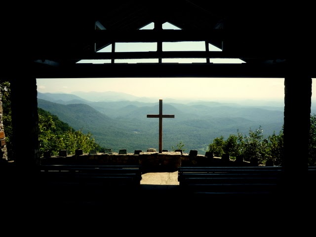
There is a pretty place I have found.  In fact, it is referred to here as Pretty Place -- actually the Symmes Chapel at the YMCA Camp Greenville, whose entrance is about 2.7 miles north of Caesars Head on US-276, almost at the North Carolina state boundary line. 

You wind your way into the camp on Soloman Jones Road from 276 for about 5 miles, partly in North Carolina, but returning to South Carolina along the way.  The road gets narrow and mostly unmarked, so use some caution.  There is considerable traffic when weddings or camps are going on, especially on weekends. 

Many weddings are held in the chapel at the end of the road, but if there is one scheduled, there will be a hand-lettered sign on the right side of the road so indicating, at the lake, a bit more than 4 miles from the main road.

The chapel, built in 1941, is a pleasant spot to relax and enjoy the view while you are out on the bike.  (There are restrooms during the warm seasons.  Whew.)

View from inside the chapel. 

A much prettier picture of the view was captured by my friend Fred in the fall of 2010:
Photo courtesy of Fred
It is indeed a pretty place.  Other great pictures can be found on the 'net

On the way back home, I stop for a few minutes at Caesars Head.  The short walk to the overlook finds a sizable group of people watching for falcons, but I manage to shoot a panorama of the valley.  That mountain in the center above the lake is the back side of Table Rock Mountain.  You can see the far side very well from Table Rock State Park.


The road down the escarpment to the south of Caesars Head is very twisty, but can be fun when there isn't too much traffic.  Going up is easier, as usual

Here is the route from Caesars Head, at Pushpin A, to the camp turnoff at Soloman Jones Road, Pushpin B.  The sign for weddings will at C, and Pretty Place is at D.
Click here for an interactive map
Come visit Pretty Place and be inspired. 
.
.

Thursday, January 17, 2013

Back Toward Table Rock

.
One of the most prominent sights near where I live is Table Rock.  I have written about it several times, including here, and here.  You can see if from miles away.  Here is a view of the Rock taken from 15 miles away as the crow flies, on a recent winter day. 
It is that bare rock to the right of the highest peak. 

But because it is so easy to get to, and because it is so attractive, I go there, or go past there, often.  I have taken snapshots from several vantage points, but a couple of weeks ago, I stopped along a different road to get another one. 

I wandered up Carrick Creek Road and found that the view was quite nice, and the sky was beautiful that day. 

While I was stopped, these guys (gals??  Hey, I'm a city boy.  OK?  ...and they were a fair way off.) were paying attention to their lunch nearby. 
 

In the park, these are views over Pinnacle Lake.  


Now, this is a great photograph, taken by Fred, a work associate.  My snapshots pale in comparison. 

By the way, also along Carrick Creek Road is this waterfall.  It is on private land, so you can't go down to it, and it is usually rather anemic, but with some recent rains, it has become much fuller.  There is a place to stop on the road overlooking the falls -- at Pushpin A on the map below. 


By the way, if you are adventuresome, enlarge the map above and look for the foot trails leading up to the top of Table Rock and Pinnacle Mountain Trail.

Next time you go past this landmark, take a few extra minutes to really enjoy the views.

.

 .

Sunday, April 1, 2012

Quick Trip to a Familiar Place

.
The weather and my schedule have conspired to keep me off the bike for a couple of weeks.  I ventured out on a rainy Saturday morning this weekend, however, taking a chance that the weather would be at least tolerable.

It was!  I didn't have a lot of time to spend, so around sixty miles was all I rode, but it was certainly worthwhile. 

From Easley, I go over to Pickens and up US-178, which is moderately curvy, to SC-11, the Cherokee Foothills Scenic Highway, where the Holly Springs Country Store is that bikers gather at.  No others are there, so I turn right on 11, and ride to Table Rock State Park.  There is a visitor center there. 

I take this photo of Pinnacle Mountain from the parking lot of the visitor center.  It is the highest point entirely within South Carolina.  You can hike up there if you have a strong heart and leather lungs.  It is a strenuous climb of four hours, six miles round trip, with an elevation gain of 2673 feet.
Your head might be in the clouds if you do that today, but didn't it turn out to be beautiful?

From the visitor center, I cross SC-11 and go up the road into the park.  There is a pull-off with this view of Table Rock.

 Here is a better view:

Pretty, yes?  You can also hike to the top of Table Rock mountain, a moderate four-hour, 6-1/2 mile round trip with an elevation gain of 2433 feet.   

How did it get its name, you ask?  Well, according to a sign at the pull-off:
To a giant, Table Rock could be exactly what its name suggests -- a 3124 foot [above sea level] high table made of granite.  To eat at this table, the giant would need a seat -- Stool Mountain at 2600 feet served this purpose. 

That's how the Cherokee saw the memorable landscape before you.  Their beliefs, shaped by their environment, featured an enormous spirit who loomed over this mountain range, his shadow forming the bluish haze.  Sah-ka-na-ga, meaning "Great Blue Hills of God," was the name given this place. 

Settlers, influenced by the story of the gigantic chieftain dining here, preserved the legend when naming the landmarks. 
 The blue arrow is the stool.  The red arrow is the table.  

After I leave the park, I continue on SC-11 to SC-8.  The road runs to Pumpkintown, then SC-135 runs back to Easley.

I'm glad I got a chance to get out today.  I would have missed this great scenery.  Come over some time and ride.  You won't be disappointed. 
.
.
 .