.
Today I went to visit a model railroad club in Hendersonville North Carolina. It is one of those places that I found while web surfing. (Thanks again, Al Gore for "taking the initiative in creating the Internet.") It caught my eye as a place that is historic -- it is located in a 1902 railroad depot -- and is related to engineering, my profession.
Busman's holiday anyone?
Hendersonville is easy to get to from home, taking mostly well-paved two and four-lane roads. There is some city traffic at both ends to contend with, however. My plan is to take a few lesser-traveled roads, and to photograph a railroad trestle I spotted a few days ago when I went out for a quick evening ride.
Here is the route I had planned for the day.
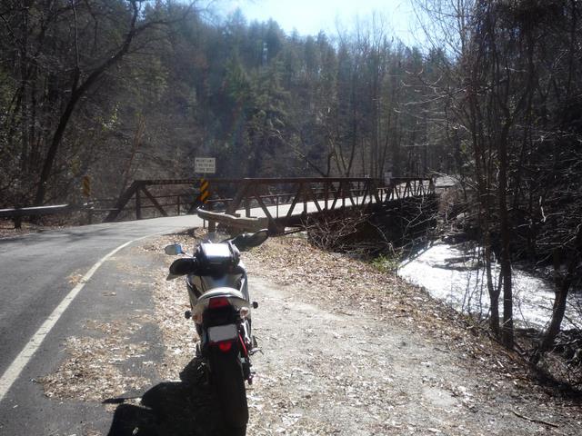
The trestle is located parallel to Saluda Dam Road at the Pickens/Greenville County line and runs over the Saluda River. It is quite rusty, but is used every day. A train is just passing when I ride up. I hurriedly stop and pull out my camera to get a shot -- just as the last car goes out of sight. Oh well, maybe another one will come by while I am here.
I wander along the highway bridge and take a few pictures. There is a house down near river level with quite a number of "collectables" in the yard.


There is also evidence, in the form of additional concrete piers, of another bridge having been across the river.

Perhaps this was an earlier highway bridge, replaced in 1980 by the one I am standing on. The Shadow standing over the bridge's date stamp.

The track that runs over this trestle is the
same line that runs through downtown Easley, carrying both freight and passengers.
On the other side of the road, is Saluda Dam.


This is a small hydroelectric plant constructed in 1905 by Duke Power Company. It is now owned by North Brook Energy, LLC.
Others have posted photographs of this trestle. Here are a couple entitled
Trestle of Rust by their photographer,
powerwasher on Flickr.


He almost makes the photos look like paintings. There are other good pictures of sights around the area in his albums.
Here are a couple of photos by
bearden82 on Panoramio.


He, too, has a lot of good area pics.
Alas, no other trains cross the trestle while I am there, so I continue my trip. After I reach US-25, I turn north and follow it across the North Carolina line. The road is uphill for quite a long distance, though it is four lanes and easy to ride.
 Photo by M.OZ on Panoramio.
The fall colors have given way to mostly brown here at this elevation. It is still pretty, though not multi-colored as it was a few weeks back.
I trek onward to NC-225, not far from
Lake Summit that I wrote about a few weeks ago when I was "dual-sporting." This route takes me through the small town of Flat Rock, a mostly retirement and tourist-oriented town.
On the north side of Flat Rock, it says that 225 ends. I am puzzled by this, as I thought it went right into Hendersonville. I stop and study the Google map to no avail. I decide to continue on business US-25 and I find myself in Hendersonville within ten seconds. I guess Flat Rock and Hendersonville don't have any space between them.
I follow the map to the train depot on Maple Street and scope out possible parking places. I like to find a spot that is protected from auto damage yet visible. I decide to circle around the depot, so I cross the tracks and follow Boxcar Street, which I find has a short stretch of gravel, potholes, and mud. Before getting to the bad spot, there is a good place to take a picture of the track side of the depot.

I edge through the gravel and mud and come back to Maple Street again. I pick a spot on the sidewalk near the building, park, take off my gloves and helmet, set my alarm and head for the entrance.
My sometime riding companion, who I picked up in
Lawrenceville Georgia, has decided to stay with the bike again today. You can just barely see him sitting there on the seat behind my gloves.

Note that my right turn signal has fallen off. I must have bumped it on something.
The depot is nicely restored on the outside. I go inside and find it attractive as well.
A little history from the club's website:
"The current structure...is actually the second station.... The first station was built shortly after the Southern Railway reached Hendersonville as a narrow gauge line late in June 1879. This was ten years after Coast-to-Coast service was established through Ogden Utah. The first station for all practical purposes was a duplicate of the Saluda station, which still stands in that village. By 1902 the station proved to be too small to handle the ever increasing traffic and was moved across the tracks, North of 7th Avenue where it was used as a Freight house for many years.
"The present station was started in 1902. Originally it was 87 feet long and consisted of two waiting rooms (a white and a black), an Agents Office, indoor plumbing, and a freight or Railway Express Office. The total cost of construction was $2613.00 which included three coats of heavy oil-based paint. In 1906 15’ feet was added to each end of the station to provide a Ladies waiting room, and more baggage handling space. A few years later an open pavilion was added to the North end of the station to provide an additional covered waiting area. This addition was still not enough to handle the crowds of customers. On some Saturday mornings, especially during the summer, between 500-600 young campers waited for the train to come up the Saluda Grade for their return trip home. When the train arrived it would disgorge approximately another 500-600 young campers for the next camping session.
"In 1916 another 50 feet was added to the roofed over, open pavilion waiting area making it 75 feet long and reaching all the way to 7th Avenue. Soon after the last passenger service ended in 1968, this open pavilion became the unofficial unemployment office for the City of Hendersonville.
"In its heyday, a 22,000 gallon water tank stood on the other side of the tracks with underground pipes to two stand pipes in between Track #1 and #2, just far enough apart for two Mikado steam locomotives to be serviced at the same time. At its peak, six passenger trains a day stopped in Hendersonville collecting and discharging passengers for our City, while making their way from as far away places as Cincinnati and Charleston.
"[The adjoining] track is still claimed to be the steepest Class #1 railroad in the United States [having a] 600’ elevation [change] in less than 3 miles between Saluda and Melrose. While passenger service ended in 1968, thousands of tons of freight, particularly coal and wood chips, traveled over these tracks and through the Hendersonville station with as many as 6-7 trains a day up until 2002. At that time the current owners, Norfolk Southern Railroad, elected to re-route trains South by selecting different routes thereby by-passing Hendersonville. Except for occasional local deliveries to area industries the tracks at the Hendersonville Station sit quietly beside the station providing a nostalgic reminder of the hustle and bustle of years gone bye.
"While the station still belongs to the Norfolk Southern Railroad, it is leased to the City of Hendersonville who maintains the building. In the year 2000, the building was registered by the North Carolina Historical Society as a Historical Landmark commemorating its long and useful history in serving the public and residents of Henderson County."
I take off more of my gear, leaving my tee shirt and leather pants and stow the rest on a bench. Since it has been cold this morning, all the stuff I had on fills the bench up completely. I approach one of the club members, a fellow named Bob. He says he is a modeler himself. His working career was spent mostly in the information technology (IT) field, from mainframes on down. I ask him about the club's origins and activities.
He says the
Apple Valley Model Railroad club was formed many years ago and moved into the depot in 1992. The building had not been occupied for some forty years, was complete with pigeon droppings, and had been vandalized. They have an agreement with the city that they can use the building as long as they are open to visitors every Saturday between 10 AM and 2 PM.
Why is it called Apple Valley, you ask? Well, this area is known for its fine and varied crop of apples. In fact, they host the
North Carolina Apple Festival right here in Hendersonville every September. It is quite a nice celebration; with the streets filled with vendors and all the stores open.
The club's first layout in this building was built shortly after occupying the depot. That section represents the general Asheville North Carolina area. A second phase of the layout was built between 2005 and 2008. The overall layout dimensions are 18 x 100 ft (0.3 scale miles x 1.6 scale miles), 1700 ft (28 scale miles) of track, and 225 turnouts (switches for you non-train readers). The trains are controlled by Digital Command Control (DCC), a system that allows multiple trains to run on the same track with individual control by several "engineers" at once. The scenery has taken thousands of hours to complete.
The club is getting ready to rebuild the oldest section of the layout to freshen it up and improve reliability. Today, several members are priming pieces of lumber and sheets of plywood to reduce the effects of temperature and humidity changes.
I also meet Terry, another member. He says he is a fellow motorcyclist, riding a Kawasaki Vulcan for about a year now. He asks me about learning to ride, so I tell him about the
MSF Basic Rider's and
Total Control classes I have taken. He happens to give a talk to visitors about the Saluda Grade, and he was interested in
my blog entry about it. By the way, the tracks that run by this depot continue over to Saluda, so they are seldom used any more because The Grade is no longer in operation.
Here are some shots of the layout.

A large articulated locomotive, frequently used in mountainous areas to haul heavy freight.

A roundhouse and turntable.

The Saluda North Carolina Station looks like the real one,

though the real station in Saluda has been moved from its original trackside location to this spot across the street and perpendicular to the tracks.


Some of the members operating their trains.

Real looking water in this lake.

A logging crane.

A great, curved wooden trestle.

The club has set up a kid-height layout that they can operate themselves. This little lady was controlling
Thomas the Tank engine,...

while a pair of twins were controlling Emily, another engine.

You can see how fast Thomas is going -- he's just a blur. Note the authentic Chick-Fil-A billboard in the upper picture with its the suicidal cow.
Do remember my little riding buddy? Well, he's created a bit of a stir outside, as related by a couple of people in the depot who recognize that I must be the motorcycle rider whose bike is parked there. Apparently they stopped to take a closer look at my friend, and the proximity sensor caused the bike alarm to squawk at them. I wish I had seen their reactions. I'll bet my buddy enjoyed the little trick, too.
Outside is this bright red caboose.

As I prepare to leave, I see that an older gentleman, two ladies, and a younger man are walking up the sidewalk. The gentleman asks me a few questions about my bike. As I describe it to him, the others go along ahead to see the trains. As she walks away, his wife turns to me and says, "You'll need to just walk away from him, because he'll talk your arm off."
It turns out that the man's name is Carl, he is eighty eight years young, and lives in Greenville South Carolina, maybe fifteen miles from where I live. Ordinarily, I would not call someone who is significantly my senior by his first name, but in almost all cases in this blog, I use only a first name to preserve the privacy of the people about whom I write. That is the case here, too, so Carl it shall be.
For some reason, Carl asks me if I know the significance of the date December seventh. I answer that I do. At that, Carl begins to tell me about some of his life. It turns out that Carl was in the military, stationed at Pearl Harbor beginning on December 4, 1941, when he was about twenty years old.
On the morning of the seventh, his squad was positioned somewhere that he could see Hickam Army Airfield, but not the harbor. He and his unit were doing practice exercises where half of the troops were designated blue, the other half red, to prepare them for possible action.
He says he spotted planes that were flying over the harbor, painted with the Japanese rising sun on their sides. He thought they were part of the exercises and pointed them out to his squad saying, “Those are the enemy, boys.” He says he did not immediately realize that they were indeed enemy attackers, even after they began to drop bombs on the airfield.
He telephoned his superior to tell him that there had been a mistake – that the planes participating in the exercises were bombing our own planes on the airfield. His superior, apparently not aware of the bombing that had begun, accused Carl of being drunk. Carl placed the call a second and third time as other waves of planes came in, finally convincing his superior that these were really the enemy. He was then ordered to shoot them down if they could.
Carl also spoke of their having been warned of a possible invasion from the sea. Some time after the bombings, his squad noticed something bobbing in the surf. It struck him that there appeared to be only one invader rather than a larger group. Carl took a pistol shot at this invader, but he continued to bob in the surf. He says that he knew he wasn’t that bad a shot to have missed, but next took a rifle and shot at the intruder again. This, too, did not dispatch this enemy. Carl then took a bayonet, waded and swam out into the surf, and speared his target – which turned out to be floating debris from the bomb carnage.
After the war, Carl had a bad case of survivor’s guilt – questioning why had he survived and so many others had not. An officer explained to him that there are no victors if no one returns from war. Carl says he had never considered that, and has been able to reconcile his guilt as a result.
After the war ended, Carl and his wife moved to California, bought a new car and a house trailer. They proceeded to circumnavigate the United States, heading east in the southern states, then north in the eastern states, and west in the northern states, back to California. Carl's marriage produced a daughter who he affectionately called Baby Angel.
Carl relates that one evening on his way home from work, he had an automobile accident that resulted in his being in a coma for twenty-eight days. When he awoke, he found that his wife and baby were not with him. He did not say why they had left him, but some thirty plus years later, he received a call from a woman in California seeking her father. He called her by the affectionate name Baby Angel as a test. He said her whoop of joy could almost have been heard without use of the telephone. She subsequently visited him and he her -- for a long-delayed reunion.
I am glad I stopped to let Carl "talk my arm off." Otherwise, I would not have gotten to hear his first-hand account of these significant events in his life, some of which have helped preserve my liberty and freedom.
After Carl leaves to rejoin his family, I chat for a few minutes with a former Marine, probably about forty years old, who is a member of the model railroad club, and whose car sports a conservative bumper sticker. He speaks passionately about how wrong and arrogant most of our politicians are, with their tax and spend, divisive, anti-U.S. military posture. He shakes his head as we part, indicating his extreme dissatisfaction with their behavior, and vows to encourage others to vote them out of office. He is another patriot who helped and continues to help preserve my freedom.
I am about ready to jump on the bike when I see one more thing: A vanity license plate with a good sentiment.

This fellow also displays a Blue Ridge Parkway sticker in his rear window.

Well, I have to get started for home pretty soon. I call my bride and explain where I am and why I have been detained. She says she understands -- I tend to take longer when I am out on a ride than I expect, so she has heard this before. At least she knows I am safe.
Oh. One more thing. I go back into the depot and beg for a piece of duct tape to fix my turn signal. Terry shows his generosity by offering me his entire roll. I decline his offer but elect to take a few inches of the tape instead. Duct tape fixes almost anything.
Finally, I take the same route home, stopping at an interesting church in Flat Rock,
The Episcopal Church of St. John in the Wilderness. Built as a private chapel in 1833, it is nestled into a very wooded site, literally surrounded by its graveyard.

Better heed this sign.

It would be interesting to spend some time reading epitaphs here.
I don't tarry long at the church, and I turn south to retrace my path. I intend to cut off of US-25 and take Gap Creek Road down to SC-11. This is a curvy secondary road that has some nice views. You can see some pictures and a description
here.
Unfortunately, I blow right past it, and the divided highway makes it impossible to turn around in a short distance. I decide to go on down to Route 11, then jog over to SC-8, Pumpkintown, and SC-135 to home. After I get on 11, I go a little beyond Route 8 to the
Table Rock State Park Visitor Center. I like the view from here, and take a few pictures.
I go back a ways to the corner where
Aunt Sue's Country Corner is located, turn right there on New Hope Road, meet SC-135, and go home. This is my
actual route.
Today, I have ridden only 116.5 miles, but it has been an enjoyable day.
Other attractions near Hendersonville North Carolina:
The Western North Carolina Air Museum. Lots of historic aircraft can be seen here.
Hendersonville Antique Toy Museum. All the toys you remember when you were a kid -- and more.
Writer and poet Carl Sandberg's Home, Connemara, Flat Rock, NC.
Paddling on the Saluda River.
More Pearl Harbor information:
Pearl Harbor Raid, 7 December 1941
Japanese Navy Type 97 Carrier Attack Plane ("Kate") flies high over Hickam Army Air Field during the attack. Pearl Harbor is in the background, with smoke rising from burning ships off Ford Island and at the Navy Yard.
Photographed from a Japanese plane.
Official U.S. Navy Photograph, now in the collections of the National Archives.
Photo #: 80-G-21218

Pearl Harbor Attack, 7 December 1941
Torpedo planes attack "Battleship Row" at about 0800 on 7 December, seen from a Japanese aircraft. Ships are, from lower left to right:
Nevada (BB-36) with flag raised at stern;
Arizona (BB-39) with
Vestal (AR-4) outboard;
Tennessee (BB-43) with
West Virginia (BB-48) outboard;
Maryland (BB-46) with
Oklahoma (BB-37) outboard;
Neosho (AO-23) and
California (BB-44).
West Virginia,
Oklahoma and
California have been torpedoed, as marked by ripples and spreading oil, and the first two are listing to port. Torpedo drop splashes and running tracks are visible at left and center.
White smoke in the distance is from Hickam Field. Grey smoke in the center middle distance is from the torpedoed USS
Helena (CL-50), at the Navy Yard's 1010 dock.
Japanese writing in lower right states that the image was reproduced by authorization of the Navy Ministry.
U.S. Naval History and Heritage Command Photograph.
Photo #: NH 50931

Pearl Harbor attack information on the Shipwreck Central website.
Google map of
Pearl Harbor, USS Arizona Memorial, and Hickam Field. The airfield is almost directly south of the Arizona Memorial pushpin.
Timeline of the days before and after December 7, 1941.
Pearl Harbor Raid
Attacks on Airfields and Aerial Combat.
.


 .
.