
If you have been following this blog for more than a couple of years, you know that I have traveled to Ridgecrest North Carolina over Memorial Day weekend a few times before for motorcycle rallies. I missed last year, but wanted to get away this year to do some riding in that area, but also to be inspired by the speakers, to worship God, and honor military service veterans.
The rooming accommodations are fairly inexpensive -- $59 a night for the room, not per person -- but I wanted to hook up with someone else to share the room to keep costs down. [Surprise, surprise, Bucky being frugal!] I sent out a few e-mails to see if I could find somebody else, and finally a friend of a friend, Danny, e-mailed me back and we reserved the room. Four days and three nights.
I have previously planned out a number of routes to get to Ridgecrest and back, some via. twisty two-lane roads, and others on the superslab. That way, if the weather isn't good, I can get there using the safest route. The shortest route to get there is about 89 miles from home.
A couple of years ago, I planned to take the twisty-road route to get there, but had to backtrack and go by expressway due to heavy fog at the higher elevations. This year, the weather was superb, and the twisty route worked out almost perfectly. That 89-mile route? Well, my route ended up being almost exactly 200, and I took the whole day on Friday to get there.
Here is the twisty route:
View Larger Map of the Twisty Route to Ridgecrest
Friday.
I have been packing my luggage for a week now to get everything just right, and I have it whittled down to just enough for the four days, with a little room to spare in case I buy something to bring back.

Just before a trip like this, I am keyed up and usually don't sleep like a rock as I usually do, and this trip is no exception. Fortunately, I can sleep in a little longer than on a work day.
On the big day, I arise and get a good breakfast. I dress warmly, as there is a chill in the May air and the temperature will drop as I gain elevation. I am on the road before 8:00 with some easy riding up US-178 from Pickens South Carolina to the intersection of SC-11. This section is all sweepers and is an enjoyable way to start the day. That intersection of 11 is where bikers meet up to ride the challenging roads nearby -- and brag about doing so.
Next up is US-178 to Rosman, NC. This part is more difficult, and requires higher attention to negotiate safely. North of Rosman, is a short stretch of US-64, then starts NC-215, a continuation of great roads to ride in this part of the country. The turn onto 215 almost always is strewn with gravel, so I watch out and go slow. The road surface is recently paved, so it is nice and smooth going. It winds its way to the elevation of the Blue Ridge Parkway, about 50 miles from home, with some tight corners, and one right hander just after this bridge that also has gravel on it most of the time.
Just north of Rosman by 7-1/2 miles is the turnoff to the Pisgah Astronomical Research Institute (PARI). This was once a top-secret satellite tracking station. I visited there and took a tour back in 2009. It is certainly a very unusual and interesting place, but I have other goals today.
It is getting colder as the elevation increases. I stop just a half mile south of the Parkway at a large gravel overlook.

I turn on the grip heaters to keep my hands warm. That has proven to be a nice addition to the bike, and helps extend the comfortable riding season greatly. It will certainly help today.

Note the GPS mounted on the bars above. I have entered the routes I have planned for the weekend into it in the form of .GPX files generated from Google Maps. It thereby gives turn-by-turn directions both visually and by way of an earphone that plugs into a jack on the side. It also knows where I have been, so even my wildest wanderings are recorded for posterity in the form of tracks that can be viewed in various ways, including in Google Earth.
As I progress to the northeast, the weather remains partly cloudy, but there is no fog today as there was in 2011, here showing the Craggy Gardens Visitor Center parking lot:
 |
| Visitor Center near Craggy Gardens, 2011 |

Soon, I come across the road to Mount Mitchell, the highest point in North Carolina. I turn in, and follow a couple on a tandem bicycle for a short way. They are laboring mightily to climb the grade. I pass them, and get to the top, with only one switchback along the way -- it is surprising that there are not more tight curves, being that this is a high point. I reach the parking lot at the top, and pause for a proof-of-visit shot.

I simply enjoy the road as I continue on my day's journey, so there aren't any pictures from the next section. The overlooks are more overgrown along the Parkway north of Asheville, so there isn't as much to see anyway. The best part for sightseeing is between Asheville and Cherokee, the latter being the southern terminus of the Parkway. When I ride that stretch, I stop often to gawk at creation.
My GPS says it is time to turn right onto North Carolina route 80 toward the south. I do so, and make it a point to stop at the Parkway exit. There is a large parking area, there. I want to do something to make myself more photogenic. [A peacock, are we, Bucky?]
Well, I have checked with the photographer Blind Kenny, who hangs out on 80 every weekend. Actually, it is both he and his wife who hang out just south of the Parkway on a left hand curve. I have stopped to take off my fluorescent MSF safety vest -- to make myself pretty for the camera....pretty as best I can, anyway.
I start down the hill on 80. It has a considerable drop -- 2000 feet in twelve miles. It is known as the Devil's Whip, formerly the Devil's Staircase-- a marketing ploy, I am sure.
The part I am on has some serious switchbacks. Look in the upper left corner of this map:
View Larger Map of the Devil's Whip
And here is a stylized map of the road:
 |
| From the Devil's Whip website. |


In fact, the toe of my left boot touches the tarmac, right about here:

Hmmmm. I wonder, did they get a good shot? I decide to make certain that they have the greatest opportunity. After all, this is their livelihood we're talking about here.
Besides, I have to get my feet in the right position.
At the first wide place in the road, I turn around and go back up the hill. I am not traveling as fast as before, but they pan their cameras as I go by. (At least, I suppose they are panning their cameras -- I am too busy paying attention to the road to look their way.)


Now, since I have to go south in the end to reach my destination, I must turn around at the Parkway and make one more run.

(Yep, they were panning.)
I head on south. The road is quite technical in places, and fairly easy in others. South of Pushpin B on the map above, there are many residences, so you have to be careful of other vehicles. Where it is safe, I stop and shrug on my brightly-colored vest again, so other vehicles have a better chance of seeing me. I am a bit disappointed when I reach US-70. It is lined with houses and businesses and is almost straight to my next destination, Old Fort. There won't be any more roads with curvy challenges today.
This little town has a few points of interest, one of which is a giant arrowhead at the old railroad depot.
The arrowhead was erected back in July of 1930, and is hand chiseled from granite.

Here is the dedication ceremony announcement:
 |
| From the Old Fort website. |
There was once a fort close to this little town, built by the colonial militia before the Declaration of Independence, and the settlement served for many years as the western-most outpost of the early United States.
 |
| From the Old Fort website. |
Next, I go a few miles to another interesting thing on my list today. Along the way to view it, I see glimpses of the railroad right of way, on its torturous path upgrade on the so-called Old Fort Loops. If you look at this section of the Google map, you see how the railroad twists and wraps around to minimize the grade.
View Larger Map of the Old Fort Loops
Click on "View Larger Map" above and then enlarge and move around the general area to see the railroad right of way that roughly parallels the road. You can follow it all the way from the depot in Old Fort, Pushpin A on the map, to the Ridgecrest Conference center at Pushpin "D."
The railroad route is about thirteen miles, but only about five as the crow flies. They certainly put in a lot of civil engineering to get it built. Mr. James W. Wilson, who lived between 1832 and 1910, was the chief engineer and president of the Western North Carolina Railroad, planned and built this section. There is a commemorative plaque to Mr. Wilson back at the depot.
The road I am on has a few turns, but soon enough I come across the desired point of interest, Andrews Geyser, at Pushpin B on the map. Now you may have thought that geysers only exist in Yellowstone National Park in the western United States and at a few other places in the world. Well, you would be right about that. The truth of the matter is that there are no natural geysers near here. This one is man made, and is actually better described as a fountain.
From Wikipedia:
The fountain is named for Colonel Alexander Boyd Andrews, a North Carolina native who was the Vice President of the Southern Railway Company and one of the men responsible for the construction of the railroad between Old Fort and Asheville, North Carolina, in the late 1800s. The fountain was constructed in 1885 with a dual purpose: it was a feature of the Round Knob Hotel, and a tribute to the approximately 120 men who died building the railroad through this particularly treacherous stretch of land, that culminates with the crossing of the Eastern Continental Divide through the Swannanoa Tunnel. The fountain was said to be eye-catching for railroad passengers ascending the 13 miles of track and seven tunnels that peaks at the top of Swannanoa Gap because it could be seen several times along the route. The Round Knob Hotel burned to the ground in 1903, and the fountain fell into disrepair. In 1911, George Fisher Baker, a wealthy New York financier and philanthropist who had been friends with Colonel Andrews, funded its restoration. The Southern Railway Company did not grant continuation of the easement for the fountain at that time, so a new, five-sided basin was constructed about 70 yards across Mill Creek, and the piping and nozzle were moved (to the fountain's current location). The town of Old Fort was given rights to the basin and the pipe that carries the water, and the fountain was formally named Andrews Geyser.The Inn on Mill Creek is run by the Walters family. I e-mailed and called them a couple of times for updates on the status of the geyser, and on road conditions. They were very cordial and helpful.
The town of Old Fort continues to use Andrews Geyser and the surrounding area as a public park. Andrews Geyser underwent extensive restoration again in the 1970s, and was rededicated on May 6, 1976. Signs at the park describe Mr. Fisher's role in the early 1900s and the role of Old Fort's private citizens in the 1970s in keeping the fountain running. Andrews Geyser shoots water continuously to a height of about 80 feet. Its water supply is drawn from a pond located at the current site of the Inn on Mill Creek, a local Bed and Breakfast. The Inn's property contains the original dam constructed by the railroad in the late 1800s, and the pond formed by the dam with the water of the Long Branch of Mill Creek. A 6-inch diameter cast iron pipe runs from the dam, through a hidden gate valve, then underground approximately two miles downhill to the fountain. The water comes out a half-inch nozzle pointed skyward, and the 500 feet of elevation difference creates the pressure that drives the fountain.
While I am stopped at the geyser, a train rumbles into view, making its slow way uphill toward Ridgecrest. Actually, I have heard it rumbling for a long while, since it is slow going for it in these hills.

The geyser, with the train in the background:

The road just to the west of the geyser turns to mostly well-graded gravel. I stop for a picture of what almost looks like a model railroad scene.

Today, at the point where the road turns to gravel, there is a sign advising that the road is closed. Like almost any typical motorcyclist, I continue on anyway, past the Inn, until I am stopped by a power shovel whose width is just a little less than that of the road. The gravel road had washed out in a few areas in the previous weeks of heavy rain, and they are fixing it.
I stop to ponder my predicament. The work crew spots me, and waves me on past the shovel, but in the ditch next to the road. I motion that the space is too narrow. They take another look, acknowledge that it is, and start up the giant machine to move it two feet further from the ditch -- and closer to the edge of the road they just filled in, and the steep slope down. I had visions of the power shovel slipping down the embankment. Fortunately, it didn't, at least not while I was there. The space the operator opened up looks wide enough, but the men had spread some loose soil on the far side of the equipment that I will have to plow through. I ponder that for a few seconds, then, in fine dirt-bike fashion, I give it the gas aggressively, stand on the pegs, and slither through it. I stop for a second, a little surprised at my success, frankly. One of the workmen says I will encounter one more machine further ahead. Oh, joy. Well, I've gotten this far. Let's see what's ahead.
Actually, I encounter five large dump trucks in line waiting to dump their loads. They are parked in the road so there is not enough room to get by on the uphill side, but there are three or four feet of space on the downhill side.
And, boy, is it down! A steep dropoff from the edge of the road, maybe 50 feet down. I steel my nerves, literally say to myself "look where you want to go," and go. I get by these obstacles all right too, but I'd rather not be so close to a recently-filled edge with no guardrail whatsoever.
The gravel road ends at Old US-70, and it is only a very short way to the Ridgecrest Conference Center, my destination. I park in front of the main building, take off my helmet and gloves, and go in to register.

I decide to visit a high overlook on the campus, the Eagle's Nest, before I go to my room. There is a narrow road all the way up, with some gravel, but the view of the adjacent valley and I-40 is very nice.

And view, I do, for a few minutes in this quiet place.

A nearby sign is a good reminder.

After a few minutes, I mount up, go back down the little road, find my room, and unload the bike.
I notice that a few bikes are already here.

Well, this is different:

And here is an old veteran:

How'd he get that leviathan in there?

More heavy stuff.
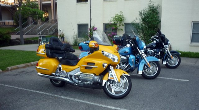
I am seeing triple. Too many tail lights.

Looks like I'm still a minority

A trailer queen.

This:


And one naked sportbike:

I change out of my riding gear, shower, and prepare for supper. I start to spot some familiar faces from previous rallies, and the group from near home has arrived. The food here at Ridgecrest is always tasty, and they start out proving it again this year: Pork tenderloin, seasoned green beans, and baked potatoes. All of it is excellent. I won't lose any weight on this trip!
We assemble in a large room, where we hear about the coming events of the weekend, and we have a short singing and worship service.
Afterward, the seminar I choose -- one amongst a dozen or so -- is given by a former policeman, Ed Obaugh, on Protect Yourself in Court. I hope never to be on trial in a court, but I could still be called as a witness for some reason. It is good to know what to do, anyway. The presenter is a devoted Christian, and it shows in his speech and actions. His descriptions of incidents in his career show, too, his Christian character.
After the seminar, several of us sit in a row of rocking chairs outside on a porch, like a bunch of old folks. [If the shoe fits, Bucky...] We discuss the day's activities, and plans for the next day. I am tired from the ride, and turn in. Danny comes into the room a few minutes later, we chew the fat a bit, but are soon sawing down massive forests big time.
It has been an enjoyable day, with more to come.
Links to related postings:
Rally to Ridgecrest, 2013 -- Day 1
Rally to Ridgecrest, 2013 -- Day 2
Rally to Ridgecrest, 2013 -- Days 3 and 4
Freedom is Never Free! -- Rally to Ridgecrest, 2011, Part I Freedom is Never Free! -- Rally to Ridgecrest, 2011, Part II
Rally to Ridgecrest Facebook Page
Memorial Day 2010 Weekend Rally
Memorial Day 2010 Weekend Rally, Part II, The Ride Up
Memorial Day 2010 Weekend Rally, Part III, Saturday
Memorial Day 2010 Weekend Rally, Part IV, Sunday and the Ride Home.
.

.


