Wednesday, October 16, 2013

The Parkway, Some Knobs and Rocks, and a New Twisty Road

.
I have ridden the Blue Ridge Parkway from its closest point, where it intersects NC-215 toward the north many times.  The furthest north I have been on the bike, near milepost 292 outside Blowing Rock, NC was when I went to the Rally to Ridgecrest in 2011.  Other posts about the Parkway include this one and this one.  The scenery along this section of the Parkway is nicest, the road is in good condition, and it makes for an enjoyable time out. 

I have not ridden to the south on the Parkway (the direction is actually more northwest than south on this part of the road) as often, so I set out to change that by notching up a trip.  A look at the map reminded me of a place I have been a couple of times before, and I opened my scope a little to see if there were other places to go that I haven't been to.  I was successful on the latter, so come with me on this slightly longer-than-usual-for-me ride. 


I start out on familiar roads, US-178 from Pickens South Carolina to Rosman North Carolina.  This includes that sweeping-curve stretch, from Pushpin A on the map below to about 1/3 of the way to Pushpin B, that is fun to ride with little difficulty.  Today, there is not much traffic, as I have begun my ride early -- about 8:00 in the morning -- so it is clear sailing.


View Larger Map

This road, north of SC-11 at Rocky Bottom, has been closed for several months while they were fixing a slide that took out part of the road.  That work is complete now, so I go right through.  At this early hour, the sun is low and it is hard for the eyes to adjust as you go from light to shady spots, especially when looking to the rising sun in the east.  The trees have also begun to shed their leaves in places, and they lay on the pavement disguising any gravel and other nasty road features.  As a result, I am not too speedy through here.


I get into some fog at Rosman, and it raises fears that the day will not be clear after all, though the weather guessers said that is not to be the case.  A few miles north of Rosman, the fog dissipates, and is not a problem all the rest of the day.  In fact, by its end, the entire day will have been clear with occasional clouds.  In short, a beautiful time to be out. 

NC-215 from Rosman north was repaved a couple of years ago, so it makes for a smooth ride.  (If it weren't for those fallen leaves all over the place.) There is a scattering of gravel on the road in places including, as usual, on the right-hander just after this bridge, here


View Larger Map

As I proceed to the higher elevations it gets a little cooler, so I am glad I wore some long underwear and a fleece shirt under my riding suit.  And the heated grips take the chill off of my hands.  In a few short weeks, it will be time to put on the Hippo Hands again.  Boo.  But here is my method of keeping warm despite the weather.  You can ride almost year around in these parts, so I just gear up as necessary.  In fact, there is an on-line forum for the intrepid motorcycle rider who endures the heat and/or the cold

The closest entrance point to the Blue Ridge Parkway is a little over 50 miles from home, so it takes just an hour or so to get there.  The entrance is typical of many, with a stone-faced overpass and a nearby entrance ramp.


The Parkway south is smooth and there is little traffic.  I pull over onto some of the overlooks along the way, and find great panoramas unfolding at almost every turn.  There is the slight change of color in the leaves already, and there are clouds in some of the valleys in the distance.  I traveled through one of those clouds at Rosman (it is called fog when you are in it, by the way -- a little science lesson). 

One of those panoramas is at the Courthouse Valley overlook at milepost 423.5: 

Click to see a larger view.
Not much further, there is the Cowee Mountains overlook at the 430.7 mark:


I stay a while at each one to drink in the scenery. God must have used a mighty fine paintbrush to give me these views today. 

Next up is the highest point on the Parkway, at the 431 milepost.  The elevation here is 6,053 feet above sea level.  Home is at 1,079 feet, so I have climbed about 5000 feet, not counting the ups and downs along the way.  I don't snap the usual photo in front of the sign because there are some other riders doing it.  This older photo will have to do, taken on a trip to the Wheels Through Time motorcycle museum in Waynesville North Carolina: 


I reach the second of my titular points, sooner than I thought I would.  I glance at my trip odometer, and see that it is only 85 miles from home, at the 451.2 milepost.  "Why haven't I come here more often if it is that close?" I ask myself. 

What is this place that I should have been visiting more often?  Waterrock Knob.  You can find it at Pushpin B on the map at the top of the posting. Click on the link below the map to move around and enlarge it so you can see the details better. 

It is uphill from the unusual divided lanes at this point on the Parkway, and just before the main parking lot is a little overlook for Browning Knob.  It is named for R. Gerry Browning, a Location and Claims Engineer and Parkway consultant who secured its right of way through here.  There is a good view of the road I came in on from here as well, in the background. 


The parking lot for Waterrock has only a few cars, and a couple of bikes.  I park, and make my way to the comfort station -- a block outhouse, basically.  It is locked, thanks to Obama's government shutdown caused by his stubbornness in not cutting the budget permanently.  I am not certain that locking an outhouse is going to save much money.  Instead, it raises my anger toward this man who is bent on destroying the American economy, and, indeed, our way of life. 

So I prepare to make other arrangements. 

I note that about half of the people I see have pained expressions on their faces as though they desperately need a solution to a pressing problem, and the other half have looks of blissful relief on their faces having found an alternate arrangement already.  

After that, I can view the scenery with a little less stress.  ...and, boy, there is plenty of scenery visible here. 

This is the panorama toward the west: 


It is only another 18 miles from here to the southern terminus of the Parkway, near Cherokee, NC.   Surprisingly, I have not ridden there yet.  Maybe next time. 

And here is the view to the east: 


Beautiful, both.

If you climb to the top of Waterrock Knob, you can see even further.  Here is a picture taken a couple of years ago from the top: 


You can see the parking lot in the center, and the Parkway winding from the left from whence I came today, and wrapping around the right, heading toward the camera, and on to Cherokee. 

I mount up and wander back about seven miles the way I came, to the exit from the Parkway at the Great Smokey Mountain Expressway, US-23 and US-74.  This four-lane road is an expedient way to get where you are going, but not very interesting to ride.  I run down about 9-1/2 miles toward Sylva, then cut over onto NC-107. 

Now take a look at the map of my return trip, so you can follow along: 


View Larger Map

Right near Sylva is the start of a few roads I have not ridden before.

As I motor along, I spot a sign for Judaculla Rock, at Pushpin C, a place I have had in my database of  places to visit in future.  [Bucky, keeps a database of stuff like that?  ...Must be an engineer, or something.]

Why, yes, I am an engineer by training, now that you mention it. 

I didn't know I was going to pass near this rock today.  I turn off on Caney Fork Road, and go about three miles to the end of a side road that veers to the left.  There, I find a flat soapstone rock maybe sixteen feet across upon which Indians carved various features between around 500 and 1200 A.D. 

From the above website:
Judaculla Rock is North Carolina’s best known and largest example of an American Indian petroglyphs site. In the modern and generic sense, it is a public attraction and a point of interest, and is commonly identified as a boulder covered with ancient and mysterious engravings....

Judaculla is the anglicized pronunciation of Tsul Kalu,...a legendary giant.... Judaculla was a human-like giant with supernatural powers, who traveled between This World and the Underworld....
View from the parking area.  The rock is in the center of the curved observation platform. 

The carved face of the rock:. 

For this 1930s photo, the cryptic markings were filled with chalk. Since this valuable picture was made, the rock has continued to erode, making serious study increasingly difficult.
photo courtesy Jerry Parker, former owner of the land on which the rock sits. 

This little guy is sunning himself on one of the stone pillars, but keeping a wary eye on me.


Quite photogenic, he is. 

Shortly after I leave, I cut over onto NC-281, also known as Canada Road.  This route is said to be better for twisties and with less traffic than the parallel NC-107.  I find that to be true. 107 is a good road, mind you, but this one is better -- and I have not been on it before. The surface is generally good. 

The scenery unfolds among a continuing series of turns.  Occasionally, I can see a lake in the distance or some other great scenery, but mostly I am watching the road for its next contortion.  I'll bet there are a lot of riders who would use this as a racetrack challenge.  

I come around a tight right-hand bend and immediately before me is the T. Fields Dam holding back Wolf Creek Lake.  The dam is a not-very-attractive structure with a concrete spillway, and there is almost no room on either side of the road to walk, so be careful.  I stop in the gravel pulloff and look around. 

The stone-faced earthen dam.
The concrete spillway, also showing the narrow space between the road and the railing. 
Looking downstream from the dam spillway.  The water is an eerie green color. 
View of Wolf Creek Lake.
I spot this sign from the parking area, warning you that the water below the dam can rise rapidly, depending on the spillover volume.  The sign clearly states the danger.  


Someone cleverly defaced the sign so it conveys another message, quite effectively, I might say. 


Canada Road continues on for several miles, and there are some fun twisty sections along the way -- not much traffic, not many driveways, and not many crossroads. Watch out for a hairpin or two. 

The road comes near Silversteen Road, a neat twisty ride I couldn't get enough of back in November, 2011.  I don't take that way, as my backside is getting a little fatigued from the seat time today. 

281 joins US-65 for a short distance, then turns south again and passes Gorges State Park.  This is a road with mostly sweepers, but with two or three tighter turns.  I am moving right along, for me, and I am holding good lines through the curves.  I am enjoying the road quite a lot.  It passes Whitewater Falls, a place I have visited many times before, that is quite picturesque, the falls dropping 411 feet. 

There appears to be a problem, however, as I pass the falls entrance.  There are cars parked along the highway for some distance in both directions.  I slow down, and then see the reason.  Obama again -- there is a yellow tape across the entrance: The falls is administered by the U.S. Forest Service

See the tape on the left behind the SUV? 


 This is what Obama doesn't want us to see today:


Too bad.  Now, I have only seen a park ranger here once before, so it is not as though the park is highly patrolled.  Anyway, those people parked along the road have to hike into their park, and their cars, trucks and motorcycles create a potential hazard on the edges of the highway.  I wonder: What would happen if the yellow tape somehow happened to get broken?  [Naughty, naughty thought, Bucky.]
Just so you know, I don't yield to my temptation, and go on about my ride. 

The road becomes SC-130 just south of Whitewater Falls, right near the Duke Power Bad Creek Pumped Storage Facility (where there is a nice overlook and where the gravel Musterground Road starts).  130 is loaded with sweeping curves on almost all of the ten miles to SC-11.  I carry a good speed through here as well, and reach that intersection in jig time. Watch for a few places where the top layer of pavement has spalled off. 

The route home is easy roads, and I am enjoying the hum of the engine and the wind coming at me. By the time I reach home, I have covered about 212 miles, on a beautiful clear day. 


Other Good Places Near the Route I Took:

  • A Sportbike Route by Wayne Busch of Smoky Mountain Motorcycle Rider blog.
  • A route including Charlies Creek Road, Ellijay Road, Becky Mountain Road, and Explorer Road.  [175 mi, 5 hours]
  • Dolphin Rock, about here, just beyond the dam I crossed.
    Dolphin Rock taken by bcool of Carolina Riders Forum

.

.

Friday, October 4, 2013

Right Great Ride Routes to Remember

.

Back in the middle of August, I was riding around one Saturday, and stopped at the Holly Springs Country Store for a little rest, and to wet my whistle.  As I turned into the driveway, I spotted a young man dribbling motor oil from well above the filler opening, trying to get some to go into the crankcase of his Yamaha V-Star metric cruiser. 

I stopped nearby, took off my gloves and helmet, then walked over to see if I could help him.  He had no funnel, and he was getting more oil on the pavement than into the gizzard of his bike.  I held the bike up straight for him so he could pour more accurately. 

He finished his pouring, and thanked me for helping, then introduced himself as Jay.  As we were talking, I noticed that his license tag was from Florida, and he had some luggage on the tail of the bike. I asked him about his ride today and how long he had been riding. 

He was a talkative guy, and explained the details of how he came to own a motorcycle, and why he was there today.  He said he had become interested in riding some months ago, traded his old car even for the bike, and only then took a class to learn how to ride it.  He said it sat in the garage until he took that class.  That seems smart to me.  That's what I did back in 2007.  Now carless, he rides the scooter wherever he goes if he can't walk there.  He says he has ridden about 4000 miles so far, and had never been on roads that were not flat before this trip.

He related that he had just come down from Sassafras Mountain, the highest point in South Carolina, about 12 miles from the store.  It is a place I have visited many times before, at Pushpin B (Pushpin A is where the store is located):   

View Larger Map

He said that Sassafras was the last of the highest points in seven states he had visited over a period of a week.  He didn’t have much with him -- a tent, a sleeping bag, and a small clothes bag strapped onto the bike, and he said that he had spent all of $90 on lodging for the week.  

Interesting.  I wondered where these seven peaks are.  

I looked up the Seven Summits Tour on the Internet, but came up with something a lot different: Many people, extreme adventurers, think of climbing to the highest points on the seven continents when they hear about Seven Summits. 

These:
  • North America’s Denali,
  • South America’s Aconcagua,
  • Asia’s Mount Everest,
  • Europe’s Mount Elbrus,
  • Africa’s Kilimanjaro,
  • Australia ‘s Mount Kosciuszko, and
  • Antarctica’s Vinson Massif.
For those who are less adventuresome ‑‑ and who have shallower pockets ‑‑ the seven might instead be the highest points in seven southeastern states, listed here with their elevations above sea level: 

All of these high points have roads to or nearly to their tops, so you don't have to turn up your pacemaker to get to any of them, and you can leave your hiking boots behind.  For someone who has only previously ridden on flat roads, he has certainly gotten a dose of twisties by now, traveling to these places and in between.  

I have visited Sassafras Mountain many times, and Mount Mitchell is easily accessible from the Blue Ridge Parkway. I have been there twice on the bike. 

This route might be a good way to get to these seven high points in the most expedient way.  


View Larger Map

I calculate about 1450 miles going this way, avoiding most major four-lane highways.  

Anyway, back to talking with Jay. 

I also noticed that his jacket had an embroidered logo, “Florida Free Rides,” so I asked him what that was, thinking maybe it was a biker group.  He explained that he owns a company by that name in Clearwater Beach Florida.  They have a fleet of electric carts that ferry people from hotels to attractions and back for free.  He says he makes his money by selling the advertising space on the sides of the vehicles, and his drivers make theirs through tips from happy riders. 

That is Jay at the back of the cart pictured here:

Jay continued the conversation, recounting some of the places he had been so far on his trip, that he had had trouble finding some of the high points, and his adventure of riding the Tail of the Dragon.  On the latter, he said that he had no trouble going the speed limit there, but others were much faster than he. 

He observed that, "In Florida, you get a ticket if you speed, but in the mountains, your penalty is a trip off the edge of a mountain."  

True enough.  I reminded him that we do use the sides of our tires here in the mountains, contrary to those riders in, say, Florida.  He thought about that for a moment, looked down to examine his tires, and said that he now realized that very fact. 


Here is another, shorter route that takes in the highest point in Kentucky, Black Mountain (4,145 ft), but skips Florida (its high point is only a relative pimple, you know), Alabama, and Mississippi:


View Larger Map

This route is about 628 miles. 


And if you skip Kentucky, Florida, Alabama, and Mississippi, and leave just South Carolina, North Carolina, Tennessee, and Georgia, you get this route:


View Larger Map

420 miles: A long day, but doable for many.


Maybe I could try it some time, or split it into two days to include some signtseeing along the way.

What do you think?  Do you have a Right Great Ride Route to Remember?

Other Info of Interest:
.

.

Sunday, September 22, 2013

Skyuka Mountain Road

.
A while back, I heard that retired local professional cyclist George Hincapie and lots of other bicyclists like to ride a certain road up near Columbus North Carolina, about 55 miles from home.  Its name is a bit unusual, as you may already have noticed above -- Skyuka Mountain Road.

From SKYUKA.ORG website: "The name Skyuka is used to identify the mountain ridge rising to the north of Tryon, NC, consisting of Warrior, Round, and Miller Mountain to the west, Tryon Peak, and White Oak Mountain to the east. One or more of these mountains were named for the Cherokee chief Skyuka who signed a treaty with the British in 1767 defining this mountain ridge as the line of demarcation between Cherokee and British territory."

Now you know.

I Googled the road and gazed at its tortured path.  Since it wasn't far away, I mapped out a route to see this wonder of roadbuilding expertise.  I have been to Columbus, Tryon, and some other towns nearby before on the bike, so off I went on this route.  The roads of interest are around Pushpins D through G:

View Larger Map


From home in Easley South Carolina, the route starts out easy on SC-135, SC-186, then SC-414 to Pushpin B on the map.  From there it is a few miles on US-25 to Old US-25, heading to Saluda North Carolina at Pushpin C. 

I have been to Saluda many times.  The road going there is steadily uphill, and mildly twisty.  My friend Ryan showed me the way one day back in March of 2008, about six months after I started riding.  Unfortunately, the road surface is not very good, with lots of bumps and one or two heaves that threaten to throw a rider off his bike if he doesn't happen to be holding on very well.

I turn right in Saluda onto NC-176.  If I were to follow this road for a few miles it goes down the Saluda Grade to a place called Melrose.  This section of road is much more fun going the other way -- up the grade.  It is wide in many places with slow vehicle lanes, and the surface is good enough to promote some spirited riding.  Be careful, though, there are some pavement defects that can step your tires sideways, and give you more of a thrill than you expected. 

Today, I elect not to take 176, and, instead, turn right onto Pearson Falls Road.  It immediately becomes well-groomed gravel that is easy to ride on almost any bike.  There is little traffic, and it winds its way through a forested area roughly parallel to the railroad track that is the steepest in the United States.  I've been through here before, so I know what is ahead.  There is an interesting tunnel under the tracks that is also a bridge carrying a creek beneath its roadway.
2009 photo
Another direction I could have gone from Saluda is on the most contorted road I have ever been on, Green River Cove Road.   My then new friend Ryan lead a group ride about three weeks after my first trip to Saluda with him that included Green River Cove Road -- and he took us downhill on it! I recall forcing myself to look almost backward around the hairpin bends.  I wobbled down with a death grip on the bars, but finally made it to the bottom, and onto a much easier stretch.  Oh.  In addition to Ryan, the other riders in the group included a fellow, Don, who was 74 years young at the time.  He was quite a good rider on his standard bike. 

Back to today's ride.

Pearson Falls Road passes Pearson Falls, a little private park with a nice waterfall, then connects again to NC-176, and I head east toward Tryon.  This stretch of road has pavement heaves every few hundred feet, so it is not a pleasure to ride it.  Soon enough, though, I reach NC-108, and the start of Skyuka Road, which connects me to Skyuka Mountain Road in about a mile, just after crossing over I-26/US-74.  Skyuka Mountain Road begins with a steep upgrade, and the switchbacks start almost immediately.  This one is just after Pushpin D on the map: 

Click on the link beneath the map to enlarge it so you can see how twisty the road really is. 

Here is a video done by Golden Carper in July of 2010, going the same way I went. 


I reach the top, and this wonderful panorama unfolds before me:
Click the pic to see it larger.
These views are at Pushpin E, where Skyuka Mountain Road ends and White Oak Mountain Road begins.  Somewhere down there is Holbert Cove Road, where I've ridden before.  


I stay a few minutes to take in God's creation below me.  Right next to this little gravel pulloff, there is a large house...
...with this sign:

I understand, even with the poor grammar.  ...and I don't plan to stay the night anyway.  

I continue on a short way, and find another great view, across the road from a large group of condominiums. The view:
Click the pic to see it larger. 
That is Columbus North Carolina down there.  I again stop and drink in the scenery.  Wow!  This is at Pushpin F.  

The condos:

There are a lot of other roads up here, but most of them have gates across them to keep the likes of bikers out.

Before the houses and condos were built was the thirty-two room Skyuka Hotel.
Photo from GoUpstate article by
It was built in the 1880s and torn down in the 1940s. 

On its foundation, a Dining and Recreation Hall was built for the later YMCA Camp Skyuka.   The camp opened in 1954, but closed in the mid-1980s. 

A few of the buildings that were part of the camp have been converted into houses and to other uses, including the Skyuka Mountain Lodge.  The former Dining and Recreation Hall mentioned above is currently for sale -- $579,000 -- if you are interested. 

The location of the lodge is right here:

View Larger Map

A history of the area may be found in an article on the website for the homeowners association of what is now called Camp Skyuka. 

Back to the ride, the trip down. 

The road from Pushpin F, White Oak Mountain Road, is not as long or as twisty as Skyuka Mountain Road, but it is just as scenic, maybe more. One neat thing is a large waterfall, right next to the road. 

This is Shunkewauken Falls, which drops 500 feet down the mountain.
Photo by Zarrendragon on Photobucket
That is a much better picture of the falls than I took because the trees obscured the view, but there was much more water when I was there because of recent heavy rains.   Be careful if you stop to look, as there are few places to park safely. The spot where the photo was taken is at the sharp turn to the right and below Pushpin F, below. 

View Larger Map

By the way, there is a short stretch of one-lane road to the left of Pushpin F.  Apparently there was not enough room to make it two lanes wide. 

I couldn't find a video showing the route down, but here is a video from LetsRideClyde (Terry Taylor), going up, the opposite of the direction I rode.  For reference, the waterfall is at 7:05, the one-lane section is at 8:29, and the condos are at 8:53. 


I make it down and travel on my way toward home.  The views from on high are still fresh in my memory.

The roads back are pretty easy, and I am enjoying them, too.  You can grab and move around on the map below to see other points of interest.  If you have time, don't miss Poinsett Bridge and Pleasant Ridge County Park along the way. 


Recap Map:

View Larger Map and Scroll Around

I only rode 129 miles today, but I saw some great sights.  Come along next time for more interesting roads and sights in the Upstate of South Carolina, and in western North Carolina. 


Other Riders' Rides Up and Down

  • Golden Carper rode up White Oak Mountain Road in 2010, opposite of my route.  (He misnames it, in his title.)  The one-lane section is at 4:48, and the crest is at 5:26. 
  • kalafroski rode up White Oak Mountain Road in 2010 on his supermotard, the reverse of my route.  The waterfall is at 4:10, the one-lane section is at 5:28, the summit is at 6:28.  
  • Terry Taylor of LetsRideClyde rode down Skyuka Mountain Road, opposite of the way I came, starting from Pushpin F.  The previous overlook, the one with the ungrammatical sign, is at 2:03 in his video.  
  • Terry Taylor's website, LetsRideClyde, has GPS overlays that show good motorcycle routes and Points of Interest [POI].   There are also ride videos on roads in North Carolina.  

.

 .

Wednesday, September 11, 2013

We Must Never Forget

.
We must never forget what Islamist terrorists did to us in 2001.  


They are growing stronger and our political leadership is studiously ignoring and denying the danger. 

We must stand strong against them forever and always, lest the freedom of this greatest country on earth be lost forever. 
.

Monday, September 2, 2013

Sprockets on the Docket

.
A while back, you may recall that I installed a new chain on my 2006 Kawasaki Ninja 650R.  The symptoms back then almost felt like the engine was missing, especially in the lower gears under hard acceleration, but try as I might, I could not find evidence of that. 

As it turned out, after some 25,000 miles, the original chain had stretched more in some places than in others, so the effective drive ratio was changing a few times with every circuit the chain made around the sprockets.  The new chain solved the problem of the unevenness I was feeling. 

I didn't change the sprockets at the time, because they did not appear to be worn enough to justify it.  Most advice says to change the sprockets at the second chain replacement.  Of course, the front sprocket was worn more than the rear because it is smaller and each tooth contacts the chain more often -- about three times more often than the rear sprocket since there are about three times the number of teeth -- 46 -- on the rear vs. the front -- 15. 

With the new chain, the drive was smooth again, so I had not thought any more about it until a few weeks ago.  The unevenness had come back. 

Now what could be wrong?  Has my "new" chain already worn out?  It is only 14,000 miles old.  Have the old sprockets damaged the new chain? 

I check the chain for stretch at several positions along its length.  That doesn't seem to be an issue. 

What next? 

The front sprocket shows some hooking of the teeth, the rear less so.  Well, the likely culprit is the front sprocket, but I decide to change both in case the rear has worn just enough to be a contributor to the problem. 

To the Internet, then, to do some shopping! 

I search ebay and Amazon, and a few of the on-line bike parts sources, but find the best prices for OEM sprockets at Ron Ayers.  You can buy aftermarket sprockets, certainly, but the front original has a rubber cushion built in for noise and harshness reduction.  I want to maintain that feature that most aftermarket sprockets do not provide.  As long as I am buying the front, I go ahead and buy the rear and the countershaft-locking washer too. 

I press the magic computer buttons, and the order is placed. 

A few days later, the parts arrive, and I commence with the surgery. 

First comes removal of the sensor that counts countershaft revolutions so the fuel injection computer knows what is going on, and so the speedometer and odometer register properly -- albeit the speedo has always been about 5 MPH optimistic at 60, though the odometer is correct. 

That was easy.  On to the next step. 

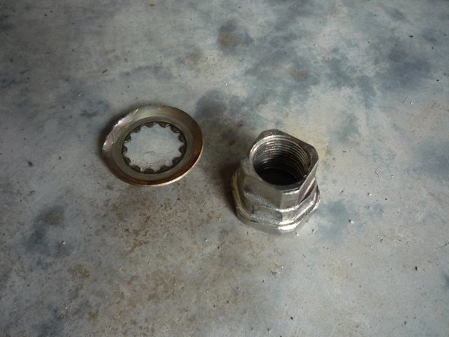
The front sprocket has that lock washer that prevents the nut on the countershaft from loosening.  It does that by your bending its edge against one of the flats on the nut.  I straighten out the washer, and get out the air impact tool I bought when the Tractor Supply store opened here and the 27mm impact socket I bought at O'Reilly Auto Parts.  (Don't try to use a 12-point conventional socket; it will round over the corners of the nut.)  I fire up the air compressor, ask my wife to help me put the bike on the rear stand, and to hold the rear brake while I apply the impact tool to the nut.  I remember to put the transmission in neutral so the engine doesn't turn while this is going on, because it could cause damage. 

The impact tool sounds like a giant angry woodpecker, clacking away, but this woodpecker has no discernable effect whatsoever on removing the nut; it remains firmly in place.  I guess that is good -- it certainly wouldn't have come off accidentally. 

I examine the visible threads inside the nut and use my engineering logic to conclude that this is, indeed, a right hand thread, and that I am not trying to tighten it instead of loosen it.  It is. 

I try the impact tool again.  And again.  My wife is getting tired of holding the rear brake, and she lets me know that. 

Finally, I hear the familiar "brrruuup" of an impact tool unzipping a fastener, and the nut comes off of the shaft. 

The locking washer and the stubborn nut, free at last: 

Whew!  I had had visions of having to take the bike to a shop just to get that nut loose...and the mechanic taunting me like I am a 98-pound weakling for not being able to get it off. 

I thank my wife for her help with a smooch and a hug (I hope I am not too greasy), then get back to the task at hand.  I loosen the rear wheel to put some slack in the chain, and the front sprocket comes off easily. 

There is a large amount of accumulated chain lube around the sprocket, so I clean that out. 

I remove the rear wheel, and use the impact tool and the appropriate impact socket to remove the six sprocket retaining nuts.  A little cleaning up of chain lube from around that area, and I am ready to start reassembly. 

I carefully examine the service manual for the correct torques, and get out my trusty torque wrench. 

The rear sprocket goes on easily.  I apply molybdenum disulfide/oil assembly lube to the new front sprocket splines and to the face of the nut, then loop the chain around and install the sprocket and washer.  I snug the nut, but I have to wait for the rear wheel and chain to be installed before I can torque it because I need the rear brake applied to keep the shaft from rotating as before.  (For that, I have to go get my wife again.) 

I position the chain around the rear sprocket, and reinstall the rear wheel.  I tension the chain by tightening the nuts on the two tension studs, making sure the alignment markings display the same, side to side. 

I tighten the rear axle nut and recheck the chain tension, because sometimes tightening the axle causes the chain tension to change a bit.  It hasn't this time. 

I also remember to check the chain tension at its tightest point.  You do this by rotating the rear wheel and feeling when the chain has the least amount of droop on the bottom, or return, side.  If you don't do this, there is a chance that the chain will be too tight when the suspension is deflected while riding.  This could cause expensive damage to the countershaft and its bearings. 

I call for my wife to come out again.  She drops what she is doing, and appears, wondering how long it is going to take this time.  I assure her that this will only be a short tenure this time (I hope).  She holds the brake pedal as I tighten the countershaft nut to the 95 ft-lb spec.  I use the impact socket on the torque wrench for the same reason as when removing the nut -- to keep from rounding off the corners of the nut. 

I again check chain tension and everything is good.  I bend over the edge of the countershaft lock washer so it is against a flat on the nut.  Don't want that coming off, now do we. 

Everything looks OK, so I put the RPM sensor and the front sprocket cover back on.  I install the cotter pin in the rear axle nut, and tighten the chain tension stud jamb nuts.

An application of lube to the chain is next.  
I slip a sheet of corrugated behind the chain to keep from squirting the tire.  I'd rather not see what the effect of that might be. 

Ready for a test ride. 

I suit up, and take it for a little spin.  I try some quick accelerations and pay attention to the feel, and whether the problem still exists.  The unevenness is greatly reduced. 

I think this may have fixed it.  The only thing better would be to have replaced the chain again, but I am not made of money, so that will have to wait a while.  

Lesson learned: At least replace the front sprocket when replacing the chain.  Here is a picture of the old next to the new front sprocket.
What do you think?  Was it time for a replacement? 


Resource to help investigate final drive sprocket ratio changes: Gearing Commander
.
.

.